 | Snežniška Grda jama - Snežnik (via Mali Snežnik)
Snežnik or Veliki Snežnik is the highest peak in the near and far surroundings with a height of 1796 m. It offers a beautiful view over most of S...
1 h 25 min |
 | Gašperjev hrib - Snežnik
Snežnik or Veliki Snežnik is the highest peak in the near and far surroundings with a height of 1796 m. It offers a beautiful view over most of S...
1 h 30 min |
 | Gašperjev hrib - Snežnik
Snežnik or Veliki Snežnik is the highest peak in the near and far surroundings with a height of 1796 m. It offers a beautiful view over most of S...
1 h 30 min |
| Sežanje - Snežnik
Snežnik or Veliki Snežnik is the highest peak in the near and far surroundings with a height of 1796 m. It offers a beautiful view over most of S...
1 h 40 min |
 | Bistriška planina - Dobrča
Dobrča is a 1634 m high mountain located between Begunje and Tržič. From the top, where the registration box with the stamp is located, we can se...
1 h 30 min |
 | Hibje - Dobrča (by road)
Dobrča is a 1634 m high mountain located between Begunje and Tržič. From the top, where the registration box with the stamp is located, we can se...
1 h 45 min |
 | Črni Kal - Blegoš (by road, via hut)
Blegoš is a 1562 m high mountain located between Selška and Poljane Sora. From the grassy summit, on which there is a stamp and a registration bo...
1 h 30 min |
 | Črni Kal - Blegoš (direct way)
Blegoš is a 1562 m high mountain located between Selška and Poljane Sora. From the grassy summit, on which there is a stamp and a registration bo...
1 h 10 min |
 | Črni kal - Blegoš (via Prva ravan)
Blegoš is a 1562 m high mountain located between Selška and Poljane Sora. From the grassy summit, on which there is a stamp and a registration bo...
1 h 20 min |
 | Bohinjsko sedlo - Možic (direct way)
Možic is a 1602 m high peak located west of Soriška mountain pasture. It is at the highest point of the peak that there is an old military bunker...
1 h 15 min |
| Bohinjsko sedlo - Možic (by Lajnar)
Možic is a 1602 m high peak located west of Soriška mountain pasture. It is at the highest point of the peak that there is an old military bunker...
1 h 30 min |
 | Hunting cottage (Davča) - Porezen
Porezen is a 1630 m high mountain located between Davča and Baška Grapa. From the top, where a large NOB monument stands, we have a beautiful vie...
1 h 45 min |
 | Podhočar - Porezen
Porezen is a 1630 m high mountain located between Davča and Baška Grapa. From the top, where a large NOB monument stands, we have a beautiful vie...
1 h 50 min |
 | Volovljek - Kranjska reber
Kranjska reber or Peak Kašna planina (1435 m) is a volcanic mountain. From the top, where the registration box with the stamp is located, we have...
1 h 20 min |
 | Črnivec - Kranjska reber
Kranjska reber or Peak Kašna planina (1435 m) is a volcanic mountain. From the top, where the registration box with the stamp is located, we have...
1 h 30 min |
 | end of road on Vogar - Pršivec (direct way)
Lookout Mountain is located above Lake Bohinj. The view is extensive on all sides. Triglav and the mountains around it can be seen, and on the ot...
1 h 30 min |
 | Planina Dol - Konj
Konj is a 1803 m high peak located between Velika planina and Presedlje. From the top, we have a beautiful view of the highest peaks of Kamnik Sa...
1 h 30 min |
 | Rateče - Ofen/Peč (footpath)
Peč (also Tromeja), in Italian Monte Forno and in German Dreiländereck or Ofen, is a 1508 m high peak located on the tri-border between Slovenia,...
1 h 40 min |
 | Rateče - Ofen/Peč (eastern path, past bivouac and on footpath)
Peč (also Tromeja), in Italian Monte Forno and in German Dreiländereck or Ofen, is a 1508 m high peak located on the tri-border between Slovenia,...
1 h 45 min |
| Rateče - Ofen/Peč (eastern path, past bivouac and on mule track)
Peč (also Tromeja), in Italian Monte Forno and in German Dreiländereck or Ofen, is a 1508 m high peak located on the tri-border between Slovenia,...
1 h 50 min |
 | End of road - Lepenatka
Lepenatka is a grassy peak located south of the 1557 m high Rogatec. From the top, which has a registration box and a stamp, we have a beautiful ...
1 h |
 | Tonkina koča na Vršiču - Vršič vrh
Vršič is a 1737 m high mountain located between the Postman's House and the Vršič Pass. From the top, where the registration box is located, we h...
1 h |
 | Bohinjsko sedlo - Dravh (via Lajnar)
Dravh is a 1547 m high peak located between Sorica and Soriška mountain pasture. From the uncultivated summit, we have a beautiful view of Škofje...
1 h |
| Zgornja Sorica - Dravh
Dravh is a 1547 m high peak located between Sorica and Soriška mountain pasture. From the uncultivated summit, we have a beautiful view of Škofje...
1 h 30 min |
 | Zgornja Sorica - Lajnar
Lajnar is a 1549 m high mountain located north of Soriška mountain pasture. From the top, which is also the highest point of the ski resort, we h...
1 h 40 min |
 | Bohinjsko sedlo - Šavnik
Šavnik is a grassy peak located between the Soriška planina and Kobla ski resorts. From the summit, which has a registration box with a stamp, yo...
1 h 30 min |
 | Tonkina koča na Vršiču - Sovna glava (on old road)
Sovna glava is a 1750 m high grassy peak located between Prisank and the Vršič Alpine Pass. From the top, you have a beautiful view of the peaks ...
1 h 10 min |
 | Kramarica - Smrekovec (via Bukov stan)
Smrekovec is a volcanic mountain on the eastern edge of the Smrekov Mountains. The extensive grassy summit, on which stands a pyramid with a regi...
1 h 30 min |
| Kramarica - Smrekovec (by road)
Smrekovec is a volcanic mountain on the eastern edge of the Smrekov Mountains. The extensive grassy summit, on which stands a pyramid with a regi...
1 h 30 min |
 | Predmeja - Mali Modrasovec
Mali Modrasovec is a peak north of the house on Čavno in the Trnovo forest. On the top, surrounded by wods, there is a small house and a control ...
1 h 25 min |
 | Predmeja - Veliki Modrasovec
Veliki Modrasovec is located in the southern part of the Trnovo Forest near Predmeja. On the top of the hill is an old military building which yo...
1 h 35 min |
| Predmeja (tunnels) - Veliki Modrasovec
Veliki Modrasovec is located in the southern part of the Trnovo Forest near Predmeja. On the top of the hill is an old military building which yo...
1 h 50 min |
 | Mala Lazna - Mali Golak
Mali Golak is the highest of the Golaks. It was named not because it was the smallest but because it had the smallest mountain pasture. On the ma...
1 h 25 min |
 | Kozarnice - Mali Golak
Mali Golak is the highest of the Golaks. It was named not because it was the smallest but because it had the smallest mountain pasture. On the ma...
1 h 5 min |
 | Kozarnice - Srednji Golak (via Mali Golak)
Srednji Golak is located between Mali and Veliki Golak on the plateau of the Trnovo Forest above Predmeja. The summit is covered with dwarf pines...
1 h 50 min |
 | Lokve - Poldanovec
Poldanovec is located in Govce on the northern edge of Trnovo plateau. Govci are quickly rising above Gorenje Trebuše valley. Poldanovec is not t...
1 h 30 min |
 | Turški klanec - Mrzovec
Mrzovec is the most expressing peak in heart of Trnovo plateau. His position offers us great view, but is also limited with high trees. Thats why...
1 h 30 min |
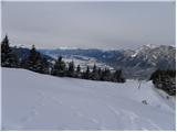
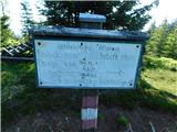
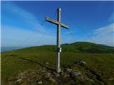
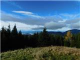
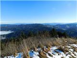
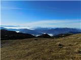
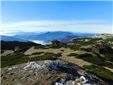
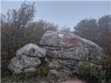
 | Grda draga - Mali Snežnik
Mali Snežnik is a peak on the west ridge of Snežnika. Vrh, which is covered with dwarf pines, has a fine view of the neighbouring Veliki Snežnik ...
1 h 30 min |
| Sviščaki - Mali Snežnik
Mali Snežnik is a peak on the west ridge of Snežnika. Vrh, which is covered with dwarf pines, has a fine view of the neighbouring Veliki Snežnik ...
1 h 50 min |
 | Koča na Naravskih ledinah - Uršlja gora (Plešivec)
Uršlja gora or Plešivec is a lookout mountain between Slovenj Gradec and Črna na Koroškem. On the top or just below it stands the Church of St Ur...
1 h 45 min |
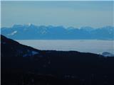
 | Jezerski vrh - Kärntner Storschitz / Pristovški Storžič
Kärntner Storschitz is an extremely scenic peak above Jezersko. It offers a beautiful view of the northern flanks of the Grintovci Mountains, thr...
1 h 50 min |
 | St. John the Baptist on Ojstrica - Huhnerkogel/Košenjak
Huhnerkogel lies north of Dravograd and the River Drava on the border with neighbouring Austria. Huhnerkogel is accessible on foot or by car from...
1 h 30 min |
 | Rifugio Pelizzo - Monte Mataiur/Matajur (via Fonte Skrila)
Monte Mataiur is a scenic mountain located on the border between Slovenia and Itali. From the top, you have a beautiful view of the Kobarid or Br...
1 h 15 min |
 | Avsa - Mrzli vrh (on Matajur) (old path)
Mrzli vrh is a 1358-metre high peak located in the Matajur Mountains. From the top, where there is a viewing platform and a registration box with...
1 h 25 min |
 | Plajberški graben / Bleiberger Graben - Sinacher Gupf / Psinski vrh
Sinacher Gupf (on maps we mostly see the name Psinski vrh) / Sinacher Gupf is a peak located north of the main chain Karawanks, more precisely no...
1 h 35 min |
 | Strugarjach / Strugarje - Sinacher Gupf / Psinski vrh
Sinacher Gupf (on maps we mostly see the name Psinski vrh) / Sinacher Gupf is a peak located north of the main chain Karawanks, more precisely no...
1 h 30 min |
 | Ljubelj - Polna peč
Polna peč, also marked on maps as Ravna peč, is located above the Ljubljana Tunnel. From the top, which is somewhat precipitous, there is a beaut...
1 h 15 min |
 | Bučan - Polna peč
Polna peč, also marked on maps as Ravna peč, is located above the Ljubljana Tunnel. From the top, which is somewhat precipitous, there is a beaut...
1 h 30 min |
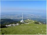
 | Platak - Snježnik (via grlo)
Snježnik is a scenic mountain in the western part of Gorski Kotar. The summit offers a beautiful view of the Kvarner islands, the Gulf of Reška, ...
1 h 30 min |
| Platak - Snježnik (via crest)
Snježnik is a scenic mountain in the western part of Gorski Kotar. The summit offers a beautiful view of the Kvarner islands, the Gulf of Reška, ...
1 h 30 min |
 | Bistriška planina - Šentanski vrh
Šentanski vrh, located in the Dobrča mountain range, only 5 minutes away from the main peak, offers a beautiful view of the central Karawanks, th...
1 h 35 min |
 | Planina Jezerca - Krvavec
Krvavec is an 1853 m high peak located in the heart of the ski resort of the same name. The summit, which is criss-crossed with cable cars, offer...
1 h 10 min |
 | Preval Vrh Ravni - Kojca
Kojca is a scenic peak rising south of Baška Grape. The hay pile on the top offers a beautiful view of the Lower Bohinj Mountains, the Škofjelošk...
1 h 20 min |
 | Koča na Starem vrhu - Mladi vrh (via Stari vrh)
Mladi vrh is the senior neighbour of the better known Stari vrh, from which it is separated by a saddle. The top is covered with a sparse beech f...
1 h 40 min |
 | Koča na planini Stador - Kobilja glava
Kobilja glava is a 1475 m high peak located east of Tolmin. From the top with a cross, we have a beautiful view of the Krn, the Lower Bohinj Moun...
1 h 15 min |
 | Torka - Gladki vrh (Ratitovec)
Gladki vrh is the most visited peak in the Ratitovec mountain range with an altitude of 1667 m. The uncultivated summit, on which the viewing pla...
1 h 20 min |
 | Torka - Altemaver (Ratitovec)
Altemaver is the highest peak of Ratitovec at 1678 m. The grassy peak offers a beautiful view of Julian Alps, Jelovica, Karawanks, Kamnik Savinja...
1 h 35 min |
 | Zgornje Danje - Altemaver (Ratitovec)
Altemaver is the highest peak of Ratitovec at 1678 m. The grassy peak offers a beautiful view of Julian Alps, Jelovica, Karawanks, Kamnik Savinja...
1 h 45 min |
 | Pod Peco/Koprein-Petzen - Topitza
Topitza, or Topitza in German, is a 1649 m high peak located northeast of Železna Kapla. From the summit, on which the cross stands, we have a be...
1 h 15 min |
| Podkraj - Srednja gora (Hrušica) (east path)
Srednja gora is a 1275 m high peak located in the central part of the forested Hrušice. The peak is covered with forest, and just a few minutes w...
1 h 30 min |
| Podkraj - Srednja gora (Hrušica) (west path)
Srednja gora is a 1275 m high peak located in the central part of the forested Hrušice. The peak is covered with forest, and just a few minutes w...
1 h 45 min |
 | Zgornje Danje - Kremant (Ratitovec)
Kremant is a 1654 m high peak located in the western part of Ratitovec. From the top, where a stamp is attached to a metal pole, we have a beauti...
1 h 45 min |
 | Soriška peč - Žbajnek
Žbajnek is a 1538 m high peak located west of Ratitovec. The grassy peak, surrounded by a rare forest, offers a beautiful view of Julian Alps, Ka...
1 h 30 min |
 | Raspet - Kopa (Cimprovka)
Kopa is a 1360 m high peak or viewing pier from which we can enjoy a beautiful view of Cerkno, the hills surrounding the above-mentioned place, R...
1 h 10 min |
 | Weinebene Straße - Weberkogel
Weberkogel is a less prominent peak located north to north-west of the Weinebene Alpine Pass. On the 1805 m high summit is a medium-sized cairn a...
1 h 30 min |
| Gasthof Pfeifferstocker - Weberkogel
Weberkogel is a less prominent peak located north to north-west of the Weinebene Alpine Pass. On the 1805 m high summit is a medium-sized cairn a...
1 h 50 min |
 | Iličev rovt / Illitsch Rauth - Kamnica (Komnica) / Ferlacher Spitze
Kamnica is a lookout mountain located on the Austrian side of Karawanks, more precisely north of Kepe. From the top, where there is a cross, a re...
1 h 35 min |
 | Avsa - Srednji vrh (on Matajur) (old path)
Srednji vrh is a 1320-metre high grassy peak located in the Matajur mountain range. The summit, which is a take-off point for paragliders, offers...
1 h 20 min |
 | St. John the Baptist on Ojstrica - Kozji vrh (at Košenjak)
Kozji vrh is a 1383-metre-high peak located above Pernice, and its height makes it the highest peak in the municipality of Muta....
1 h 35 min |
 | Bodenbauer - Kosmatica / Kosmatitza
Kosmatica is a 1659 m high peak located entirely on the Austrian side of Karawanks, north of Vrtača. The summit, which is partly covered by fores...
1 h 45 min |
 | Mönichkirchen - Steinerne Stiege
Steinerne Stiege is a less prominent peak in the Wechsell mountain range....
1 h 35 min |
 | St. Vinzenz (St. Vinzenz) - Dreieckkogel
...
1 h 35 min |
 | Knödelhütte - Hirschegger Alm (južni vrh)
...
1 h 35 min |
 | Teichalm (Angerwirt) - Osser
...
1 h 20 min |
 | Teichalm (Harrerhütte) - Osser
...
1 h 35 min |
 | Straßegg - Hochschlag
...
1 h 45 min |
 | Kohlebnerstand - Windberg (severna pot)
...
1 h 50 min |
| Kohlebnerstand - Windberg (južna pot)
...
1 h 50 min |
 | Kohlebnerstand - Hoher Klapf
...
1 h 40 min |
 | Križišče pod Zvonikom - Bitoraj
...
1 h 30 min |