 | Tominčev slap Waterfall - Dobrča
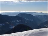
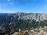
Dobrča is a 1634 m high mountain located between Begunje and Tržič. From the top, where the registration box with the stamp is located, we can se...
3 h |
 | Draga - Dobrča (via Ledena trata)
Dobrča is a 1634 m high mountain located between Begunje and Tržič. From the top, where the registration box with the stamp is located, we can se...
3 h |
 | Hudi Graben - Dobrča (via Lešanska planina)
Dobrča is a 1634 m high mountain located between Begunje and Tržič. From the top, where the registration box with the stamp is located, we can se...
2 h 35 min |
| Hudi Graben - Dobrča
Dobrča is a 1634 m high mountain located between Begunje and Tržič. From the top, where the registration box with the stamp is located, we can se...
2 h 30 min |
 | Grahovše - Veliki Javornik (Ženiklovec)
Veliki Javornik or Ženiklovec is a 1716 m high peak located between Storžič and Stegovnik. From the grassy summit, where the registration box is ...
2 h 45 min |
 | Grahovše - Veliki Javornik (Ženiklovec) (via Rekar)
Veliki Javornik or Ženiklovec is a 1716 m high peak located between Storžič and Stegovnik. From the grassy summit, where the registration box is ...
2 h 45 min |
 | Leskovica - Blegoš (on unmarked path)
Blegoš is a 1562 m high mountain located between Selška and Poljane Sora. From the grassy summit, on which there is a stamp and a registration bo...
2 h 5 min |
| Volaka - Blegoš (on unmarked path)
Blegoš is a 1562 m high mountain located between Selška and Poljane Sora. From the grassy summit, on which there is a stamp and a registration bo...
2 h 35 min |
 | Potoče - Javorov vrh (via Sveti Jakob, below Potoška gora and over Baba)
Javorov vrh (also Javorjev vrh according to some records) is a 1434 m high mountain located northeast of Preddvor. From the top, which has a regi...
2 h 55 min |
| Spodnja Kokra - Javorov vrh (via Baba)
Javorov vrh (also Javorjev vrh according to some records) is a 1434 m high mountain located northeast of Preddvor. From the top, which has a regi...
2 h 30 min |
 | Smrečje - Pečovnik (survey point 1668) (by road)
Pečovnik) is a 1668 m high mountain located between Plešivec (1801 m) and Virnik's Grintovec (1654 m). The grassy peak, located on the border bet...
2 h 45 min |
 | Rateče - Ofen/Peč (western path, past bivouac and on footpath)
Peč (also Tromeja), in Italian Monte Forno and in German Dreiländereck or Ofen, is a 1508 m high peak located on the tri-border between Slovenia,...
2 h 15 min |
| Rateče - Ofen/Peč (western path, past bivouac and on mule track)
Peč (also Tromeja), in Italian Monte Forno and in German Dreiländereck or Ofen, is a 1508 m high peak located on the tri-border between Slovenia,...
2 h 20 min |
 | Klemenčevo - Kamniški vrh (by Korošaki waterfalls)
Kamniški vrh is a 1259 m high mountain located north of Kamnik, between Stahovica and the Korošica Valley. From the top of the peak there is a sm...
2 h 15 min |
 | Klemenčevo - Kamniški vrh (on southwest slope)
Kamniški vrh is a 1259 m high mountain located north of Kamnik, between Stahovica and the Korošica Valley. From the top of the peak there is a sm...
1 h 45 min |
 | Log - Vošca
Vošca is a 1737 m high peak located west of Trupe's Non. From the grassy summit, we have a beautiful view of Julian Alps, the western Karawanks, ...
2 h 30 min |
 | Razdrto - Vojkova koča na Nanosu (Janez way)
Vojkova koča is located on the southern edge of the Nanoše plateau, close to Pleše, a peak that is clearly visible from the motorway. From the hu...
2 h |
 | Source of Ljubija - Smrekovec (via Leskovškova pustota)
Smrekovec is a volcanic mountain on the eastern edge of the Smrekov Mountains. The extensive grassy summit, on which stands a pyramid with a regi...
2 h 20 min |
| Source of Ljubija - Smrekovec (by road)
Smrekovec is a volcanic mountain on the eastern edge of the Smrekov Mountains. The extensive grassy summit, on which stands a pyramid with a regi...
2 h 30 min |
 | Mislinjski graben (Pestotnik) - Rogla (via Ostruščica)
Rogla is the peak in the middle of the ski resort of the same name. The summit is woded with a small clearing on which stands a lookout tower. Th...
3 h |
 | Smrečje - Pečovnik (by road)
Pečovnik is a 1640 m high peak located in the mountain ridge between Košuta and Virnik Grintovec. The partially vegetated peak offers a beautiful...
2 h 35 min |
 | Ivarčko jezero - Uršlja gora (Plešivec) (Grofovska pot)
Uršlja gora or Plešivec is a lookout mountain between Slovenj Gradec and Črna na Koroškem. On the top or just below it stands the Church of St Ur...
2 h 50 min |
 | Bohinjska Bistrica - Krevl (on ski track)
Krevl is a 1515 m high peak located to the south of the Kobla ski area, more precisely between Koble Peak and Kravje Črna Gora. From the summit, ...
2 h 45 min |
 | Jevšček - Monte Mataiur/Matajur
Monte Mataiur is a scenic mountain located on the border between Slovenia and Itali. From the top, you have a beautiful view of the Kobarid or Br...
2 h 30 min |
 | Podljubelj / Unterloibl - Singerberg / Žingarica
Singerberg is a peak located on the Austrian side of Karawanks above the village of Slovenji Plajberk / Windisch Bleiberg. The summit, which is p...
3 h |
 | Poljšica pri Gorjah (Zatrata) - Galetovec (on footpath)
Galetovec is an undistinguished peak in the south-eastern part of the Pokljuka plateau. From the summit, which has a registration box, there is a...
2 h 35 min |
 | Draga - Šentanski vrh (via Ledena trata)
Šentanski vrh, located in the Dobrča mountain range, only 5 minutes away from the main peak, offers a beautiful view of the central Karawanks, th...
3 h 5 min |
 | Hudi Graben - Šentanski vrh (via Lešanska planina)
Šentanski vrh, located in the Dobrča mountain range, only 5 minutes away from the main peak, offers a beautiful view of the central Karawanks, th...
2 h 40 min |
| Hudi Graben - Šentanski vrh
Šentanski vrh, located in the Dobrča mountain range, only 5 minutes away from the main peak, offers a beautiful view of the central Karawanks, th...
2 h 35 min |
 | Rateče (Ledine) - Glave
Glave are an undistinguished side ridge of the Ponce, rising steeply to the west of Planica. The highest peak of Glav, which measures 1760m, is c...
2 h 50 min |
 | Podbreg - Logarska peč
Logarska peč is a peak or viewpoint a few metres below the summit, rising steeply above the Logarska dolina valley. Logarska peč offers a very ni...
2 h 20 min |
 | Gozd Martuljek - Kurji vrh
Kurji vrh is a little visited mountain located southeast of Kranjska Gora. From the summit, which has a registration box, we have a beautiful vie...
3 h |
 | Grant - Jehlc (Špičasta kupa)
For Jehlc we will get different names on different maps, which also differ in height. The locals call the peak Jehlc (1625 m), but on more recent...
2 h 45 min |
 | Bukovo - Kojca (north path)
Kojca is a scenic peak rising south of Baška Grape. The hay pile on the top offers a beautiful view of the Lower Bohinj Mountains, the Škofjelošk...
2 h 15 min |
 | Bukovo - Kojca (south path)
Kojca is a scenic peak rising south of Baška Grape. The hay pile on the top offers a beautiful view of the Lower Bohinj Mountains, the Škofjelošk...
2 h 15 min |
 | Jesenice (Ukova) - Španov vrh
Španov vrh is a 1334m high mountain located between Javorniški Rovt and Mountain pasture below Golica. From the top, reached by the cable car of ...
2 h |
 | Jesenice (Straža) - Španov vrh (via Jelenkamen)
Španov vrh is a 1334m high mountain located between Javorniški Rovt and Mountain pasture below Golica. From the top, reached by the cable car of ...
2 h 30 min |
 | Zalog - Grebenc
Grebenc is a lesser-known peak, rising steeply above Malo and Velika Poljana. From this little visited peak, in good weather we can enjoy a beaut...
2 h 20 min |
 | Povlje - Grebenc
Grebenc is a lesser-known peak, rising steeply above Malo and Velika Poljana. From this little visited peak, in good weather we can enjoy a beaut...
2 h 5 min |
| Povlje - Grebenc (by cart track)
Grebenc is a lesser-known peak, rising steeply above Malo and Velika Poljana. From this little visited peak, in good weather we can enjoy a beaut...
2 h 5 min |
 | Dolina potoka Žep - Mali Travnik
Mali Travnik is a lesser-known peak, located south of the better-known Velika Travnik. From the partially vegetated summit, we have a beautiful v...
2 h 5 min |
 | Razdrto - Grmada (Nanos)
Grmada is a 1209 m high peak located to the north-west of the better known Plesa. From the summit, where there is a registration box with a stamp...
2 h 5 min |
 | Kal - Rušni vrh
Rušni vrh is a 1786 m high peak located to the east of Črna prsti. From the summit, which is the boundary stone of the old Rapallo border, we hav...
2 h 20 min |
 | Rateče - Monte Coppa
Kopa (also Kopje on some maps) or after ital. Monte Coppa is a 1496 metres high peak located on the Italian side of the Karavanke Mountains. The ...
2 h |
 | Radovna - Vošni vrh
Vošni vrh is a 1621 metre high mountain located in the ridge of mountains starting at Radovna and ending at Tosc. The peak itself is located in a...
3 h |
 | Ridovc / Ridovcsäge - Mejnik (via valley of Mrzli potok)
Mejnik is a 1517 m high peak located on the Austrian side of Karawanks, more precisely in the side ridge of Kosuta. There is a milestone on the s...
2 h 5 min |
 | Podvolovljek (Petkov graben) - Kunšperski vrh (Brezovec)
Kunšperski vrh, Brezovec is also a lesser known peak located west of Lepenatka. The partially vegetated peak offers a beautiful view towards Veli...
2 h |
 | Mislinjski graben (Pestotnik) - Ostruščica
Ostruščica is a 1498 m high peak located west of the ski slopes at Rogla....
2 h 30 min |
 | Podljubelj (Lajb) - Čisovec
Čisovec is a scenic peak located between Dobrča and Begunjščica. From the top we have a beautiful view towards Košuta, Kamnik Savinja Alps, Begun...
2 h |
 | Trbiž / Tarviso - Florjanka / Monte Florianca (on transport road)
Florjanka is a 1,653-metre-high mountain on the Italian side of the Julian Alps. At the top or just below it, there is a reservoir for snowmaking...
2 h 30 min |
 | Rebrca / Rechberg - Stara gora / Altberg (via Bukovnik)
Stara gora is a 1552 m high peak located north-east of Hochobir, the highest peak of the Obir. A wooden cross and a bench are placed on the summi...
2 h 50 min |
 | Bela Peč / Villa Bassa - Črni vrh / Colrotondo
Črni vrh is a fairly scenic peak located west to south-west of the Belopek Lakes. From the summit, on which the hunting observation tower is situ...
2 h |
 | Podljubelj - Robič (via Zavetišče na Kalu)
Robič is a 1384 m high peak located between the valley of Tržiška Bistrica and the ridge of Košuta. The summit offers a beautiful view, especiall...
2 h 15 min |
| Dolina - Robič
Robič is a 1384 m high peak located between the valley of Tržiška Bistrica and the ridge of Košuta. The summit offers a beautiful view, especiall...
1 h 55 min |
| Tržič (Čegelše) - Robič (via Zavetišče na Kalu)
Robič is a 1384 m high peak located between the valley of Tržiška Bistrica and the ridge of Košuta. The summit offers a beautiful view, especiall...
2 h 55 min |
| Podljubelj (Pod Košuto) - Robič (via lake Jezero pri Čežov)
Robič is a 1384 m high peak located between the valley of Tržiška Bistrica and the ridge of Košuta. The summit offers a beautiful view, especiall...
2 h 15 min |
 | Dovje - Bela peč (above Dovje)
Bele peči is a less known peak, located above the marked Dovje - Dovška Baba trail. The summit offers a beautiful view to the south and west, whi...
2 h |
| Dovje - Bela peč (above Dovje) (via Blažčeva skala)
Bele peči is a less known peak, located above the marked Dovje - Dovška Baba trail. The summit offers a beautiful view to the south and west, whi...
2 h 15 min |
 | Veliko Tinje - Veliki vrh (on Pohorje) (via Sveti Urh)
Veliki vrh is a 1344-metre-high peak located above the RTC Jakec - Trije kralji ski resort. The highest point of the peak is located in the fores...
2 h 55 min |
 | Mixnitz (Parkirišče Bärenschützklamm) - Ranerwand
...
2 h 30 min |
 | Aflenz Kurort (Freibad Aflenz) - Schönleitenhaus (Windgrube) (po južnem grebenu)
...
3 h |
| Aflenz Kurort (Bürgergraben) - Schönleitenhaus (Windgrube) (po južnem grebenu)
...
3 h |