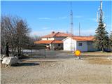
 | Lokev - Kokoš
Koča na Kokoši is located at the top of Jirmanec, just 5 minutes away from the forested Kokoša. The summit, located south of the Lokavsko polje a...
1 h 30 min |
 | Lokev - Kokoš (via source of Vroček)
Koča na Kokoši is located at the top of Jirmanec, just 5 minutes away from the forested Kokoša. The summit, located south of the Lokavsko polje a...
2 h |
 | Krvavi Potok - Kokoš
Koča na Kokoši is located at the top of Jirmanec, just 5 minutes away from the forested Kokoša. The summit, located south of the Lokavsko polje a...
1 h 30 min |
| Prelože pri Lokvi - Kokoš
Koča na Kokoši is located at the top of Jirmanec, just 5 minutes away from the forested Kokoša. The summit, located south of the Lokavsko polje a...
1 h 30 min |
 | Blečji vrh - Gradišče (via Kucelj)
Gradišče is a lesser-known peak located north of Višnja gora. From the top of the hill, where a large cross stands, there is a beautiful view of ...
1 h 30 min |
 | Straßengel - Generalkogel
...
1 h 30 min |
 | Travnarjev gozd (Hotenjsko podolje) - Šenčurjev vrh
Šenčurjev vrh is a 725-metre-high hill located above the settlement Žibrše, between Logatec, Hotedršica and Rovtami. At the top, which offers a b...
1 h 50 min |
 | Zaplana (Prezid) - Koča na Planini nad Vrhniko
Planina above Vrhnika is for hers inhabitants something like Šmarna gora for inhabitants of Ljubljana. It is 733 metres high and is reachable fro...
1 h 40 min |
 | Rein - Pfaffenkogel
...
1 h 30 min |
 | Hrpelje - Hrpeljska gora
Hrpeljska gora or Mišja šoga is a 737m high peak located south of Hrpelje. The partially vegetated peak offers a beautiful view of the surroundin...
1 h 30 min |
 | Pivka - Šilentabor
Šilentabor is a 751 m high peak located just above the village of the same name. From the top, near which there is also a bench and a registratio...
1 h 30 min |
 | Širje - Dom v Gorah
The mountain lodge in Gora is located east of Hrastnik, just a few metres below the 786m-high peak on which the Church of St George stands. From ...
1 h 20 min |
 | Legastja - Jeterbenk
Jeterbenk is a 774 m high peak located between Slavko's home at Gole Brdo and Katarina (Topol village). From the top, where there is a large cros...
1 h 40 min |
 | Veliko Trebeljevo - Obolno
Obolno is a 776m high peak located south-west of the village of the same name. The grassy summit, next to which the radio club hut stands, offers...
1 h 20 min |
 | Veliko Trebeljevo - Janče
Janče is a 792-metre-high peak located between the Sava River and the valley of the Besnica Stream. From the top, where the mountain lodge stands...
2 h 15 min |
 | Šembije - Ahac
Ahac or St. Ahac is a 799 m high peak located east of Ilirska Bistrica. The summit, which is home to a registration box, a cross and the ruins of...
2 h |
 | Zaplana (Prezid) - Ulovka
Ulovka is the peak between Zaplana and the Shelter at Mountain pasture above Vrhnika. From the top, which is reached by ski lifts, there is a nic...
1 h 45 min |
 | Mislinja - Sveti Rupert (Završe)
St Rupert's Church is situated on a viewpoint, just south of the Frice Hill. From the church or its immediate surroundings, in fine weather, we h...
1 h 25 min |
 | Zalog - Polhograjska Gora (Sveti Lovrenc) (gentle path)
Polhograjska Gora, also just Gora or Sveti Lovrenc, is an 824 m high hill located north-west of Polhov Gradec. From the top of the hill, where th...
1 h 30 min |
 | Vače - Zasavska Sveta gora
Zasavska Sveta gora is a popular excursion point located between Litija and Izlaki. From the top, where the parish church of the Nativity of the ...
2 h |
 | Kirchdorf - Predigtstuhl
...
1 h 30 min |
 | Col - Podrta gora above Ajdovščina
Podrta gora above Ajdovščina, also called the Broke Mountain above Šturje, is a mountain rising above the Vipava valley. Some time ago, a large c...
1 h 45 min |
 | Col - Sončnica (Reber)
Sončnica is a paragliding airstrip on the outskirts of the Gora plateau or Reber Ridge. There are a few benches, an automatic weather station Kov...
1 h 20 min |
 | Grčarevec - Grmada (Planinska gora) (Jakobova pot)
Grmada is an 873m high peak rising west of Planinsko Polje. The summit is overgrown, but from the lookout point just below the summit we have a b...
1 h 50 min |
 | Ravne - Loška stena
Loška stena is located above the Upper Kolpa Valley, specifically above the villages of Grintovec pri Osilnici, Ložec and Ribjek. From the top of...
1 h 50 min |
 | Mislinja - Fričev vrh (via Črepič)
Fričev vrh is an 881 m high hill located south of Mislinja Dobrava. There is no view from the top, which has a registration box with a registrati...
1 h 35 min |
 | Mislinja - Fričev vrh (via Završe)
Fričev vrh is an 881 m high hill located south of Mislinja Dobrava. There is no view from the top, which has a registration box with a registrati...
2 h |
 | Rovte - Vrh Svetih Treh Kraljev (steep path)
The Church of the Holy Three Kings is situated on a lookout above the village of Vrh Svetih Treh kraljev. From the top, which has an observation ...
1 h 25 min |
| Rovte - Vrh Svetih Treh Kraljev (gentle path)
The Church of the Holy Three Kings is situated on a lookout above the village of Vrh Svetih Treh kraljev. From the top, which has an observation ...
1 h 30 min |
 | Dom na Goropekah - Vrh Svetih Treh Kraljev
The Church of the Holy Three Kings is situated on a lookout above the village of Vrh Svetih Treh kraljev. From the top, which has an observation ...
1 h 40 min |
| Sopot - Vrh Svetih Treh Kraljev
The Church of the Holy Three Kings is situated on a lookout above the village of Vrh Svetih Treh kraljev. From the top, which has an observation ...
1 h 25 min |
 | Dule - Grmada on Mala gora
Grmada (also Grmada nad Ortnek) is an 887 m high peak located above the village of Vrh pri Poljanah in the Mala Gora mountain range. Just a few m...
2 h |
 | Velike Lašče - Grmada on Mala gora (čez Gornje Retje)
Grmada (also Grmada nad Ortnek) is an 887 m high peak located above the village of Vrh pri Poljanah in the Mala Gora mountain range. Just a few m...
2 h |
 | Jablance - Grmada (Bohor)
The Grmada Peak is located on the slope of Bohor. The summit is not scenic, but it is easily accessible. There is a partisan hospital nearby....
1 h 20 min |
 | Col - Kraguljc
Kraguljc is a mountain located between Podrto gora and Sončnica. A trigonometric point is located on the lookout point, which offers a beautiful ...
1 h 35 min |
 | Belo - Polhograjska Grmada
Polhograjska Grmada is an 898 m high peak located in the heart of the Polhograjski Dolomiti. The summit, which has a registration box with a stam...
1 h 20 min |
 | Skadanščina - Velika Plešivica
Velika Plešivica is a 908 m high peak located between Slavnik and the less known Mala Plešivica. From the top of the summit, where the destroyed ...
2 h 15 min |
 | Veliki Boč (Zgornji Kovač) - Žavcarjev vrh
Žavcarjev vrh is a 915m high mountain located north of the River Drava on the slopes of Kozjak. As the peak is completely overgrown, there is no ...
1 h 25 min |
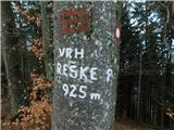 | Podmeja - Reška planina (po grebenu)
Reška planina is a peak in Posavsko hribovje, located southwest of Prebold. The marked trail does not lead to the summit, but to a nearby viewpoi...
2 h 5 min |
 | Zalog - Planica (Paragliding site Gozd)
Planica is a 926-metre-high peak located above the village of Gozd. From the top, where the JPK Kriška gora hut is located, we have a beautiful v...
1 h 30 min |
| Križe - Planica (Paragliding site Gozd)
Planica is a 926-metre-high peak located above the village of Gozd. From the top, where the JPK Kriška gora hut is located, we have a beautiful v...
1 h 20 min |
| Tržič - Planica (Paragliding site Gozd)
Planica is a 926-metre-high peak located above the village of Gozd. From the top, where the JPK Kriška gora hut is located, we have a beautiful v...
1 h 20 min |
 | Suhi Dol - Sivka (through forest)
Sivka is a grassy peak located in the westernmost part of the Polhograje Hills. In good weather, the peak offers a magnificent view from Snežnik ...
1 h 30 min |
| Suhi Dol - Sivka (by road)
Sivka is a grassy peak located in the westernmost part of the Polhograje Hills. In good weather, the peak offers a magnificent view from Snežnik ...
1 h 40 min |
 | Zagreben (pri Dikcu) - Malič
Malič is a 936 m high peak located between Celje and Laško, above Spodnja Rečica. There is no better view from the top, where the transmitter, be...
1 h 30 min |
 | Stara Fužina - Rudnica (by road)
Rudnica is a scenic mountain located between the Lower and Upper Bohinj Valley. From the top, where there is a registration box with a stamp and ...
1 h 40 min |
 | Čepulje - Sveti Mohor (Zabrekve)
The Church of St. Mohor is situated on a 952 m high hill, between Zgornja Besnica and Selce. From the church, or its immediate surroundings, we h...
1 h 30 min |
 | Podblica - Sveti Mohor (Zabrekve)
The Church of St. Mohor is situated on a 952 m high hill, between Zgornja Besnica and Selce. From the church, or its immediate surroundings, we h...
1 h 40 min |
 | Steljnik - Stene svete Ane
Stene svete Ane is a vegetated peak located near the mountain hut at Sveti Anna on Mali gora. A small observation tower stands on the summit, whi...
1 h 20 min |