 | Leskovica - Blegoš
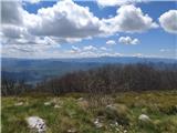
Blegoš is a 1562 m high mountain located between Selška and Poljane Sora. From the grassy summit, on which there is a stamp and a registration bo...
2 h 5 min |
 | Čabrače - Blegoš
Blegoš is a 1562 m high mountain located between Selška and Poljane Sora. From the grassy summit, on which there is a stamp and a registration bo...
2 h |
 | Tuškov Grič - Blegoš (via Črni vrh)
Blegoš is a 1562 m high mountain located between Selška and Poljane Sora. From the grassy summit, on which there is a stamp and a registration bo...
2 h 45 min |
 | Laze - Blegoš
Blegoš is a 1562 m high mountain located between Selška and Poljane Sora. From the grassy summit, on which there is a stamp and a registration bo...
2 h |
 | Hunting cottage Plehanov laz - Krim
Krim is a 1107 m high mountain rising south of the Ljubljana Marshes. From the top of the mountain, where the mountain lodge and a number of tran...
2 h 15 min |
 | Petrovo Brdo - Možic (via Vrh Bače)
Možic is a 1602 m high peak located west of Soriška mountain pasture. It is at the highest point of the peak that there is an old military bunker...
2 h 30 min |
| Petrovo Brdo - Možic (via Lajnar)
Možic is a 1602 m high peak located west of Soriška mountain pasture. It is at the highest point of the peak that there is an old military bunker...
2 h 30 min |
 | Brezje - Slivnica
Slivnica is a 1114 m high peak located north of Cerknica polje. The view from the summit, where the entry box is located, is rather limited due t...
2 h 15 min |
 | Petrovo Brdo - Slatnik (northwestern peak) (via Lajnar)
Slatnik is a scenic mountain located to the west of the Soriška mountain pasture ski resort. The grassy peak offers a beautiful view of the Škofj...
2 h 15 min |
 | Rateče - Ofen/Peč (by road)
Peč (also Tromeja), in Italian Monte Forno and in German Dreiländereck or Ofen, is a 1508 m high peak located on the tri-border between Slovenia,...
2 h |
 | Fusine Laghi - Ofen/Peč
Peč (also Tromeja), in Italian Monte Forno and in German Dreiländereck or Ofen, is a 1508 m high peak located on the tri-border between Slovenia,...
2 h 15 min |
 | Grahovše - Bela peč (via Boršt)
The mountain, which is known mainly by climbers, is located north of Storžič on the slopes of Konjščice. From the top there is a beautiful view o...
2 h 30 min |
 | Grahovše - Bela peč (via rot)
The mountain, which is known mainly by climbers, is located north of Storžič on the slopes of Konjščice. From the top there is a beautiful view o...
2 h 30 min |
 | Grahovše - Bela peč (via Rekar)
The mountain, which is known mainly by climbers, is located north of Storžič on the slopes of Konjščice. From the top there is a beautiful view o...
2 h 30 min |
 | Črnivec - Lepenatka
Lepenatka is a grassy peak located south of the 1557 m high Rogatec. From the top, which has a registration box and a stamp, we have a beautiful ...
3 h 15 min |
 | Petrovo Brdo - Kobla
The peak is located in the Lower Bohinj Mountains between Črna prst and Soriška mountain pasture. Just below the peak is a railway tunnel connect...
2 h 15 min |
 | Petrovo Brdo - Lajnar
Lajnar is a 1549 m high mountain located north of Soriška mountain pasture. From the top, which is also the highest point of the ski resort, we h...
2 h |
 | Petrovo Brdo - Šavnik
Šavnik is a grassy peak located between the Soriška planina and Kobla ski resorts. From the summit, which has a registration box with a stamp, yo...
2 h 15 min |
 | Preval - Koprivnik
Koprivnik is a 1393 m high mountain located between Blegoš and Mladi vrh. The view from the summit, which has a registration box and a stamp, is ...
3 h 15 min |
| Javorje - Koprivnik (via Brdo)
Koprivnik is a 1393 m high mountain located between Blegoš and Mladi vrh. The view from the summit, which has a registration box and a stamp, is ...
2 h 20 min |
 | Razdrto - Vojkova koča na Nanosu (gentle path)
Vojkova koča is located on the southern edge of the Nanoše plateau, close to Pleše, a peak that is clearly visible from the motorway. From the hu...
2 h 20 min |
 | Strane - Vojkova koča na Nanosu
Vojkova koča is located on the southern edge of the Nanoše plateau, close to Pleše, a peak that is clearly visible from the motorway. From the hu...
2 h 15 min |
 | Bele Vode (Rebršak) - Smrekovec
Smrekovec is a volcanic mountain on the eastern edge of the Smrekov Mountains. The extensive grassy summit, on which stands a pyramid with a regi...
2 h 5 min |
 | Ljubenske Rastke (Vrnivšek) - Smrekovec
Smrekovec is a volcanic mountain on the eastern edge of the Smrekov Mountains. The extensive grassy summit, on which stands a pyramid with a regi...
2 h |
| Ljubenske Rastke (Kumprej) - Smrekovec
Smrekovec is a volcanic mountain on the eastern edge of the Smrekov Mountains. The extensive grassy summit, on which stands a pyramid with a regi...
2 h 10 min |
 | Predmeja - Kucelj na Čavnu
Kucelj is located on the southern slopes of Trnovo Forest, north-west of the Vipava valley. From the uncultivated summit on which the cross stand...
2 h |
| Predmeja (tunnels) - Kucelj na Čavnu (via Koča na Čavnu)
Kucelj is located on the southern slopes of Trnovo Forest, north-west of the Vipava valley. From the uncultivated summit on which the cross stand...
2 h 15 min |
 | Predmeja - Mali Golak
Mali Golak is the highest of the Golaks. It was named not because it was the smallest but because it had the smallest mountain pasture. On the ma...
2 h |
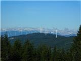
 | Gorenje pri Zrečah - Rogla
Rogla is the peak in the middle of the ski resort of the same name. The summit is woded with a small clearing on which stands a lookout tower. Th...
2 h 35 min |
 | Petrovo Brdo - Krevl
Krevl is a 1515 m high peak located to the south of the Kobla ski area, more precisely between Koble Peak and Kravje Črna Gora. From the summit, ...
2 h 30 min |
 | Ravne - Krevl
Krevl is a 1515 m high peak located to the south of the Kobla ski area, more precisely between Koble Peak and Kravje Črna Gora. From the summit, ...
2 h 20 min |
 | Dom na Paškem Kozjaku - Basališče (Paški Kozjak)
Basališče is the highest peak of Paško Kozjak. There is a bench and a registration box at the top. Due to the forest, there is no view....
2 h |
 | St. John the Baptist on Ojstrica - Huhnerkogel/Košenjak (via Bivak Piramida)
Huhnerkogel lies north of Dravograd and the River Drava on the border with neighbouring Austria. Huhnerkogel is accessible on foot or by car from...
2 h |
 | Windisch Bleiberg / Slovenji Plajberk - Singerberg / Žingarica
Singerberg is a peak located on the Austrian side of Karawanks above the village of Slovenji Plajberk / Windisch Bleiberg. The summit, which is p...
2 h |
 | Slovenji Plajberk / Windisch Bleiberg - Singerberg / Žingarica (via saddle Albink / Halbingsattel)
Singerberg is a peak located on the Austrian side of Karawanks above the village of Slovenji Plajberk / Windisch Bleiberg. The summit, which is p...
2 h 20 min |
| Plajberški graben / Bleiberger Graben - Singerberg / Žingarica
Singerberg is a peak located on the Austrian side of Karawanks above the village of Slovenji Plajberk / Windisch Bleiberg. The summit, which is p...
2 h 20 min |
 | Trojane - Črni vrh (Čemšeniška planina)
Črni vrh is the highest peak of Čemšeniška mountain pasture and with a height of 1204 m it is the second highest peak in the Posavje - Zasavje hi...
2 h 45 min |
 | Podmeja - Črni vrh (Čemšeniška planina)
Črni vrh is the highest peak of Čemšeniška mountain pasture and with a height of 1204 m it is the second highest peak in the Posavje - Zasavje hi...
3 h 30 min |
| Dom pod Reško planino - Črni vrh (Čemšeniška planina)
Črni vrh is the highest peak of Čemšeniška mountain pasture and with a height of 1204 m it is the second highest peak in the Posavje - Zasavje hi...
3 h |
 | Slovenska vas - Sveta Trojica
Sveta Trojica is a scenic peak located south-west of Javorniki. From the top, where the ruins of the former church are well preserved, you can en...
2 h 15 min |
 | Jeršiče - Sveta Trojica
Sveta Trojica is a scenic peak located south-west of Javorniki. From the top, where the ruins of the former church are well preserved, you can en...
2 h 40 min |
 | Črni vrh - Javornik above Črni vrh (via Šajsna Ravan)
Javornik is a forested peak located southeast of Črnji Vrho. In 1972, a lookout tower was erected on the summit, which reaches above the treetops...
2 h 30 min |
| Kampelc - Javornik above Črni vrh
Javornik is a forested peak located southeast of Črnji Vrho. In 1972, a lookout tower was erected on the summit, which reaches above the treetops...
2 h 15 min |
 | Podkraj - Javornik above Črni vrh
Javornik is a forested peak located southeast of Črnji Vrho. In 1972, a lookout tower was erected on the summit, which reaches above the treetops...
2 h 30 min |
 | Col - Javornik above Črni vrh
Javornik is a forested peak located southeast of Črnji Vrho. In 1972, a lookout tower was erected on the summit, which reaches above the treetops...
3 h |
 | Rakov Škocjan - Veliki Javornik (Javorniki)
Veliki Javornik is a 1,268-metre-high peak in the forested hills called the Javorniki. The vast forests of the Javorniki stretch from Postojna to...
2 h |
 | Jeršiče - Veliki Javornik (Javorniki)
Veliki Javornik is a 1,268-metre-high peak in the forested hills called the Javorniki. The vast forests of the Javorniki stretch from Postojna to...
2 h 20 min |
 | Bohinjska Bela (Podklanec) - Galetovec (western way)
Galetovec is an undistinguished peak in the south-eastern part of the Pokljuka plateau. From the summit, which has a registration box, there is a...
2 h |
| Brezje - Galetovec
Galetovec is an undistinguished peak in the south-eastern part of the Pokljuka plateau. From the summit, which has a registration box, there is a...
2 h |
 | Orehek - Kojca
Kojca is a scenic peak rising south of Baška Grape. The hay pile on the top offers a beautiful view of the Lower Bohinj Mountains, the Škofjelošk...
1 h 55 min |
 | Preval - Mladi vrh
Mladi vrh is the senior neighbour of the better known Stari vrh, from which it is separated by a saddle. The top is covered with a sparse beech f...
2 h |
 | Javorje - Mladi vrh (western path)
Mladi vrh is the senior neighbour of the better known Stari vrh, from which it is separated by a saddle. The top is covered with a sparse beech f...
2 h 5 min |
 | Ljubenske Rastke - Bezovec
Bezovec is a lesser known peak located in the Smrekov Mountains. From the top of the peak, where the hunting observatory stands, we have a beauti...
2 h 15 min |
 | Gotenica - Goteniški Snežnik
At 1289m, Goteniški Snežnik is the highest peak of Goteniška Gora. As the summit is covered by forest, the view from the summit is rather limited...
2 h 45 min |
| Kočevska Reka - Goteniški Snežnik
At 1289m, Goteniški Snežnik is the highest peak of Goteniška Gora. As the summit is covered by forest, the view from the summit is rather limited...
2 h 45 min |
 | Col - Križna gora (Hrušica)
Križna gora is a 1162 m high peak located north of the village of Podkraj. From the top of the lookout tower, you can enjoy a beautiful view over...
2 h 20 min |
 | Col - Sveti Duh (Hrušica)
The Sveti Duh Church is located just a few metres below the eponymous peak on the slopes of the forested Hrušice, a mountain range between Col, L...
2 h 15 min |
 | Predmeja - Veliki Rob
Veliki Rob is a scenic peak located between Kuclje (1237m) and Čavno (1185m). From the summit on which the cross is located, there is a beautiful...
3 h |
 | Strane - Suhi vrh (Nanos) (steep way)
At 1313m, Suhi vrh is the highest peak of the karst plateau of Nanos. From the summit, which has a registration box and a stamp (the stamp is cur...
2 h 15 min |
 | Strane - Suhi vrh (Nanos) (gentle path)
At 1313m, Suhi vrh is the highest peak of the karst plateau of Nanos. From the summit, which has a registration box and a stamp (the stamp is cur...
2 h 30 min |
| Hunting cottage Vojkovo - Suhi vrh (Nanos) (gentle path)
At 1313m, Suhi vrh is the highest peak of the karst plateau of Nanos. From the summit, which has a registration box and a stamp (the stamp is cur...
3 h 25 min |
| Hunting cottage Vojkovo - Suhi vrh (Nanos) (steep path)
At 1313m, Suhi vrh is the highest peak of the karst plateau of Nanos. From the summit, which has a registration box and a stamp (the stamp is cur...
3 h 10 min |
 | Jesenice (Ukova) - Španov vrh (Čez sedem grabnov)
Španov vrh is a 1334m high mountain located between Javorniški Rovt and Mountain pasture below Golica. From the top, reached by the cable car of ...
2 h 30 min |
 | Montemaggiore - Punta di Montemaggiore
Punta di Montemaggiore or Italian. Punta di Montemaggiore is a 1613 m high mountain located above the source of the River Nadija, on the Italian ...
3 h |
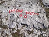 | ŽP Zrmanja - Poštak
Poštak (also "Kečina kosa") is a picturesque mountain at the crossroads of Lika and Dalmatia. It belongs to the Lika Plješivica mountain range as...
2 h 30 min |
 | Bezgovica - Cerk
At 1192 m, Cerk is the highest peak of Borovška Gora, a mountain range located between the Kolpa River valley and Goteniškje Snežnik. From the to...
2 h 55 min |
| 18th hairpin turn of road on Strma Reber - Cerk
At 1192 m, Cerk is the highest peak of Borovška Gora, a mountain range located between the Kolpa River valley and Goteniškje Snežnik. From the to...
2 h 40 min |
 | Tuškov Grič - Medrce (by road)
Medrce is a 1410 m high peak located between Porezno and Hum. From the top, where the old bunker is located, we have a beautiful view of Kojca, P...
2 h 20 min |
 | Poče - Medrce (steep path)
Medrce is a 1410 m high peak located between Porezno and Hum. From the top, where the old bunker is located, we have a beautiful view of Kojca, P...
2 h |
| Poče - Medrce (winter way)
Medrce is a 1410 m high peak located between Porezno and Hum. From the top, where the old bunker is located, we have a beautiful view of Kojca, P...
2 h 40 min |
| Poče - Medrce (via Labinjske lehe)
Medrce is a 1410 m high peak located between Porezno and Hum. From the top, where the old bunker is located, we have a beautiful view of Kojca, P...
2 h 30 min |
 | Poče - Kopa (Cimprovka) (winter way)
Kopa is a 1360 m high peak or viewing pier from which we can enjoy a beautiful view of Cerkno, the hills surrounding the above-mentioned place, R...
2 h 25 min |
 | Fusine Laghi - Monte Coppa
Kopa (also Kopje on some maps) or after ital. Monte Coppa is a 1496 metres high peak located on the Italian side of the Karavanke Mountains. The ...
2 h |
 | Petrovo Brdo - Slatnik (southeastern peak) (via Lajnar)
Slatnik) is a scenic mountain that rises steeply above Baška Grapa on one side and descends more gently towards Soriška planina on the other side...
2 h 5 min |
 | Kuna Konavoska - Ilijin vrh
Ilijin vrh or St. Ilija is the main peak of the Sniježnica Konavoska mountain ridge, which is also the southernmost mountain ridge of the Dinaric...
2 h 30 min |
 | Rehabilitation center St. Radegund at Graz - Schöckl (hiking path)
Schöckl, often spelled Schöckl, is a 1445 m high hill above St. Radegund near Graz and the southernmost of the popular peaks of the Graz Hills. W...
2 h 15 min |
 | Parking Rote Wand (Tyrnau) - Rote Wand (via saddle Bucheben)
Rote Wand is a 1505 m high mountain in the Graz mountain range in Styria, Austria. It is named "Rote Wand" (red wall) after the southeast-facing ...
2 h |
 | Zelovo - Svilaja (mimo Umaca)
...
3 h |
 | Alpl (Waldschulle Alpl) - Teufelstein
...
2 h 30 min |
 | Nechnitz - Gerlerkogel (čez Gschaidberg)
...
2 h 15 min |
 | Laufnitzgraben - Bei den drei Pfarren
...
2 h 30 min |
 | Mazinski preval - Kremen
...
2 h 30 min |
 | Kosmadei - Zastano (Samos) (no. 11 / 10)
Zastano (Greek: Ζάστανο), also known as Zestani (Greek: Ζεστάνι), with an elevation of 1206 meters, is the second-highest mountain on the Greek i...
3 h 10 min |
 | Alpl (Waldschulle Alpl) - Steinriegel
...
3 h 10 min |