 | Kališe - Kranjska reber
Kranjska reber or Peak Kašna planina (1435 m) is a volcanic mountain. From the top, where the registration box with the stamp is located, we have...
1 h 30 min |
| Volovljek - Kranjska reber (on unmarked path)
Kranjska reber or Peak Kašna planina (1435 m) is a volcanic mountain. From the top, where the registration box with the stamp is located, we have...
1 h 15 min |
 | Kosmačev preval - Črna gora
The summit is located between the Kot and Vrata valleys. A bivouac with two beds is situated on the summit. The view is fine towards Kukova špica...
1 h 15 min |
 | Dom Pristava in Javorniški Rovt - Ptičji vrh
Ptičji vrh is a 1550 m high mountain located between Barentaler Kotschna and Golica. The summit, which borders between Slovenia and Austria, offe...
1 h 45 min |
 | Kajfežev rob - Kamniški vrh
Kamniški vrh is a 1259 m high mountain located north of Kamnik, between Stahovica and the Korošica Valley. From the top of the peak there is a sm...
1 h 15 min |
 | Preval Hlevišče - Koprivnik (via Brdo)
Koprivnik is a 1393 m high mountain located between Blegoš and Mladi vrh. The view from the summit, which has a registration box and a stamp, is ...
2 h |
 | Kozarnice - Srednji Golak (unmarked eastern way)
Srednji Golak is located between Mali and Veliki Golak on the plateau of the Trnovo Forest above Predmeja. The summit is covered with dwarf pines...
1 h 45 min |
 | Jezero Sobote / Stausee Soboth - Huhnerkogel/Košenjak (po neoznačeni poti)
Huhnerkogel lies north of Dravograd and the River Drava on the border with neighbouring Austria. Huhnerkogel is accessible on foot or by car from...
1 h 40 min |
 | Avsa - Mrzli vrh (on Matajur)
Mrzli vrh is a 1358-metre high peak located in the Matajur Mountains. From the top, where there is a viewing platform and a registration box with...
1 h 25 min |
 | Zatrnik - Galetovec
Galetovec is an undistinguished peak in the south-eastern part of the Pokljuka plateau. From the summit, which has a registration box, there is a...
2 h |
 | Laze - Črni vrh above Novaki
Črni vrh, the highest point of the popular Cerkno ski centre, is located north-east of Novaky. From the summit, near which an artificial lake has...
2 h |
 | Preval Hlevišče - Mladi vrh
Mladi vrh is the senior neighbour of the better known Stari vrh, from which it is separated by a saddle. The top is covered with a sparse beech f...
1 h 45 min |
 | Cenc - Špičasti vrh (on road over Novina)
Špičasti vrh is a forested mountain located south of the village of Zadlog. To ensure that the peak is not without a view, a 13m high wooden look...
1 h 30 min |
 | Dom Pristava in Javorniški Rovt - Španov vrh
Španov vrh is a 1334m high mountain located between Javorniški Rovt and Mountain pasture below Golica. From the top, reached by the cable car of ...
1 h 30 min |
| Planina pod Golico - Španov vrh
Španov vrh is a 1334m high mountain located between Javorniški Rovt and Mountain pasture below Golica. From the top, reached by the cable car of ...
1 h 15 min |
 | Planina Lom - Kobilja glava
Kobilja glava is a 1475 m high peak located east of Tolmin. From the top with a cross, we have a beautiful view of the Krn, the Lower Bohinj Moun...
1 h 15 min |
 | Koča na planini Stador - Jalovnik
Jalovnik is a grassy peak located southeast of the slightly higher Kobilje glave. From the summit, which has a registration box, we have a beauti...
1 h 30 min |
| Planina Lom - Jalovnik
Jalovnik is a grassy peak located southeast of the slightly higher Kobilje glave. From the summit, which has a registration box, we have a beauti...
1 h 30 min |
 | Jesenice (Ukova) - Jelenkamen (via Dole)
Jelenkamen is a peak belonging to the northern Caravan Mountains above Jesenice, interesting especially for local hikers in the mountain pasture,...
1 h 20 min |
 | Koroška Bela (RC Kres) - Alničje (hunting path)
Alničje is a 1145 m high ridge rising from the SW above the settlements of Koroška bela and Javornik in Jesenik, and running NE in the direction ...
1 h 20 min |
 | Hunting cottage Vojkovo - Grmada (Nanos)
Grmada is a 1209 m high peak located to the north-west of the better known Plesa. From the summit, where there is a registration box with a stamp...
1 h 35 min |
 | Poljana - Smolnik
Smolnik is a steep 1075 m high peak - a solitary peak below Valvasor's house, rising above the Zavrh (Završnica) valley, with a view of Hochstuhl...
1 h 15 min |
 | Oblakov Vrh - Hudournik
Hudournik is a 1148 m high peak located on the northern edge of the Vojskar plateau, a plateau situated between the valleys of the Idrijca, Kanom...
1 h 30 min |
 | Makekova Kočna - Visoki vrh above Jezersko
Visoki vrh is a 1459 m high mountain located in the ridge between Makekovo and Ravensko Kočna. From the top, we have a beautiful view towards Koč...
1 h 30 min |
 | Makekova Kočna - Javornik above Jezersko
Javornik is a forested peak located between the valleys of Ravenna and Makekova Kočna. There is no view from the top due to the forest, but we ha...
1 h 45 min |
 | Makekova Kočna - Skubrov vrh
Skubrov vrh is a 1276 m high mountain rising steeply above the Ravena Koča valley. There is no view from the forested summit....
1 h 10 min |
 | Solarji - Kuk (Kolovrat)
At 1243 m, Kuk is the highest peak of the Kolovrat, the mountain range from Livko to Kambreški. The summit, which has several transmitters, offer...
2 h 10 min |
 | Livek - Kuk (Kolovrat)
At 1243 m, Kuk is the highest peak of the Kolovrat, the mountain range from Livko to Kambreški. The summit, which has several transmitters, offer...
1 h 30 min |
 | Koča na planini Kuhinja - Planica below Krn
Planica is a 1376 m high peak located south-west of Kren. The overgrown peak, which has two peaks of approximately the same height, offers a beau...
1 h 15 min |
 | Bodental - Požgani rob
Požgani rob is a 1513 m high mountain located north of Rjavka. The summit is surrounded by forest, so there is no better view, but we have a nice...
1 h 10 min |
 | Podmeja - Javor
Javor is a 1132 m high peak located between Kisovec and Sveta mountain pasture. There is no view from the top, which is covered with forest, but ...
2 h |
 | Dom pod Reško planino - Javor
Javor is a 1132 m high peak located between Kisovec and Sveta mountain pasture. There is no view from the top, which is covered with forest, but ...
2 h 5 min |
 | Matevljek - Petelinjek
Petelinjek is a 1212 m high peak located in the Racna Gora mountain range. There is no view from the summit, which is topped by a small metal cha...
1 h 15 min |
 | Sele pri Cerkvi / Zell - Pfarre - Mejnik
Mejnik is a 1517 m high peak located on the Austrian side of Karawanks, more precisely in the side ridge of Kosuta. There is a milestone on the s...
1 h 55 min |
 | Javorje - Hunting cottage Na Glinu
Hunting cottage Na Glinu is located on a lookout between the mountains Suha and Poljana. The hut offers a beautiful view of Triglav and most of t...
2 h |
 | Rotek - Erbelc
Erbelc is a 1308-metre-high peak rising steeply above Zgornja Sorica. From the summit, where the registration box is located, you can enjoy a bea...
1 h 15 min |
| Spodnje Danje - Erbelc
Erbelc is a 1308-metre-high peak rising steeply above Zgornja Sorica. From the summit, where the registration box is located, you can enjoy a bea...
1 h 15 min |
 | Rotek - Tonderškofel
Tonderškofel is a 1326-metre high peak located between Soriška Peć and Erbellec. The partly overgrown peak, which has no marked trail, offers a b...
1 h 15 min |
| Spodnje Danje - Tonderškofel
Tonderškofel is a 1326-metre high peak located between Soriška Peć and Erbellec. The partly overgrown peak, which has no marked trail, offers a b...
1 h 15 min |
 | Jeršiče - Baba (at Javorniki)
Baba is a 1085 m high peak located between the Javorniki Ridge and Sveta Trojica. From the grassy summit, we have a beautiful view of the Javorni...
1 h 30 min |
 | Bele Vode (Kovač) - Sveti Križ above Bele Vode (on south ridge)
Sveti Križ is a scenic mountain located above Beli Voda. From the top, which is home to a number of church buildings and a conversion tower, we h...
1 h 10 min |
 | Tolminske Ravne - Javor (above Tolminske Ravne)
Javor is a 1363 m high peak located between Tolminske Ravne and Grušnica. From the top, on which a small cross is erected, you can enjoy a beauti...
1 h 20 min |
 | Korensko sedlo - Petelinjek (above Korensko sedlo) (on Austrian side)
Petelinjek is a small ridge located west to south-west of Korenski sedlo. The ridge is mostly on the Slovenian side, with only the highest peak b...
1 h 30 min |
 | Polja - Petelinjek (above Korensko sedlo) (via Kališje)
Petelinjek is a small ridge located west to south-west of Korenski sedlo. The ridge is mostly on the Slovenian side, with only the highest peak b...
2 h |
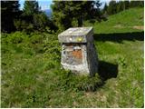
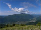
 | Polja - Kališje
Kališje is a lesser-known peak in the western part of the Karavanke Mountains. From the summit, where the transmitters are located, we have some ...
1 h 40 min |
 | Bela Peč - Ojstri vrh (above Prevala) (past peak Seduc)
Ojstri vrh is a 1,197-metre-high mountain located between Seduc Peak and Prevala. From the top, you can enjoy a beautiful view of the surrounding...
1 h 30 min |
 | Bela Peč - Ojstri vrh (above Prevala) (via Ovčje jame)
Ojstri vrh is a 1,197-metre-high mountain located between Seduc Peak and Prevala. From the top, you can enjoy a beautiful view of the surrounding...
1 h 45 min |
 | Poljšica pri Gorjah (Zatrata) - Hotunjski vrh (on footpath)
Hotunjski vrh is a 1107-metre-high lookout peak located above the Zatrnik ski resort. From the top, where there is a registration box and a bench...
1 h 30 min |
| Poljšica pri Gorjah (Zatrata) - Hotunjski vrh (by road)
Hotunjski vrh is a 1107-metre-high lookout peak located above the Zatrnik ski resort. From the top, where there is a registration box and a bench...
2 h |
 | Zatrnik - Turn (above Bohinjska Bela)
Turn is a scenic and precipitous peak located above Bohinjska Bela. From the top you can enjoy a beautiful view of Ratitovec, Jelovica, Kamnik Sa...
1 h 40 min |
 | Podblica - Bela peč (Podbliška gora)
Bela peč is located on the edge of Jelovica above the village of Podblica. From the top of the cliff we have a beautiful view of the village, the...
1 h 30 min |
 | Šumahovo sedlo - Jesenik (Jesenikov vrh) (via Veliki and Pikov vrh)
Jesenik is a 1199 m high forested peak located between Mežica and Podpec....
1 h 45 min |
 | Koča na Pikovem - Šumahov vrh (via Pikov and Veliki vrh)
Šumahov vrh is a 1155-metre-high peak on which a wooden cross is erected. From the top, which descends steeply towards Žerjav, we have a beautifu...
1 h 35 min |
 | Belopeška jezera / Lago di Fusine - Črni vrh / Colrotondo
Črni vrh is a fairly scenic peak located west to south-west of the Belopek Lakes. From the summit, on which the hunting observation tower is situ...
1 h 40 min |
 | Završnica (Pri žagi) - Tolsti vrh (at Poljška planina) (via saddle Kališča)
Tolsti vrh is a 1,225-metre-high peak located between the Završnice valley and the Draga valley. The peak is located in a forest, but from the lo...
1 h 25 min |
 | Žabnica / Bodental - Veliki Rob / Großer Rain
Veliki Rob is a 1464 m high peak located on the Austrian side of Karawanks, in the ridge above the Poden / Bodental valley. The summit has been o...
1 h 50 min |
| Žabnica / Bodental - Veliki Rob / Großer Rain (via Veronjak / Hausberg)
Veliki Rob is a 1464 m high peak located on the Austrian side of Karawanks, in the ridge above the Poden / Bodental valley. The summit has been o...
2 h 10 min |
| Slovenji Plajberk / Windisch Bleiberg - Veliki Rob / Großer Rain
Veliki Rob is a 1464 m high peak located on the Austrian side of Karawanks, in the ridge above the Poden / Bodental valley. The summit has been o...
2 h 10 min |
 | Žabnica / Bodental - Veronjak / Hausberg
Veronjak is a 1348 m high peak located above the Poden / Bodental valley on the Austrian side of the Karavanke. From the top, where there is a sm...
1 h 20 min |
| Slovenji Plajberk / Windisch Bleiberg - Veronjak / Hausberg (via Veronjak / Hausberg)
Veronjak is a 1348 m high peak located above the Poden / Bodental valley on the Austrian side of the Karavanke. From the top, where there is a sm...
1 h 25 min |
 | Zatrnik - Berjanca
Berjanca is a 1264-metre peak located above the eponymous mountain pasture. The summit used to be reached by the long-abandoned lift of the forme...
1 h 35 min |
 | Slovenji Plajberk / Windisch Bleiberg - Rabenberg
Rabenberg is a 1465 m high peak located in the Singerberg / Singerberg ridge. The summit offers some views to the north-west, but the view is blo...
1 h 45 min |
| Plajberški graben / Bleiberger Graben - Rabenberg
Rabenberg is a 1465 m high peak located in the Singerberg / Singerberg ridge. The summit offers some views to the north-west, but the view is blo...
1 h 45 min |
 | Jelendol (mansion Puterhof) - Primožkovi hribi
Primožkovi hribi is a small ridge above Jelendol, located between the watercourses of the Tržiška Bistrica, Dolžanka and Zalega potok. The highes...
1 h 40 min |
| MHE Zali potok - Primožkovi hribi
Primožkovi hribi is a small ridge above Jelendol, located between the watercourses of the Tržiška Bistrica, Dolžanka and Zalega potok. The highes...
1 h 30 min |
 | Erjavčev rovt - Bela peč (above Dovje)
Bele peči is a less known peak, located above the marked Dovje - Dovška Baba trail. The summit offers a beautiful view to the south and west, whi...
1 h 15 min |
 | Dražgoše (Na Pečeh) - Britmanca
...
1 h 10 min |