 | Aljažev dom v Vratih - Stenar (via Sovatna)
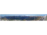
Stenar is a 2501 m high peak rising steeply above the Vrata valley. From the spacious summit, where there is a registration box and a stamp, we h...
5 h 15 min |
 | Sella Nevea - Prestreljenik (on ski track)
Prestreljenik is a 2499 m high mountain located in the heart of the Kanin Mountains. From the top, where the Aljaž Tower-shaped registration box ...
3 h 30 min |
 | The Kot Valley - Begunjski vrh
Begunjski vrh is a 2461 m high mountain located in the heart of the highest mountains in the Julian Alps. From the top, which has a registration ...
4 h 30 min |
 | Ljubelj - Begunjščica (via Zelenica)
Begunjščica is a mountain range in Karawanks east of Stol. The highest peak is Veliki vrh, which at over 2000m offers a beautiful view of central...
3 h 50 min |
| Tinčkova koča - Begunjščica
Begunjščica is a mountain range in Karawanks east of Stol. The highest peak is Veliki vrh, which at over 2000m offers a beautiful view of central...
3 h 15 min |
 | Tinčkova koča - Begunjščica (via Poljška planina)
Begunjščica is a mountain range in Karawanks east of Stol. The highest peak is Veliki vrh, which at over 2000m offers a beautiful view of central...
3 h 50 min |
 | Ljubelj - Hochstuhl/Stol (upper way)
At 2236 m, Stol is the highest peak in the Karavanke Mountains. From the summit, which has a registration box and a stamp, we have a beautiful vi...
4 h 50 min |
| Johannsenruhe - Hochstuhl/Stol (via Klagenfurter Hütte)
At 2236 m, Stol is the highest peak in the Karavanke Mountains. From the summit, which has a registration box and a stamp, we have a beautiful vi...
3 h 45 min |
| Ljubelj - Hochstuhl/Stol (via Vatelca or Skleda)
At 2236 m, Stol is the highest peak in the Karavanke Mountains. From the summit, which has a registration box and a stamp, we have a beautiful vi...
5 h |
 | Uskovnica (Lom) - Viševnik (via Srenjski preval)
Viševnik is a 2050 m high mountain rising north-west of Rudno polje on Pokljuka. From the top of the peak where the stamp is located, you have a ...
3 h 15 min |
 | Ljubelj - Vertatscha/Vrtača
Vertatscha is a 2181 m high peak located to the east of Stol. From the top of the peak, on which stands a large wedge, we have a beautiful view o...
3 h 30 min |
| Tinčkova koča - Vertatscha/Vrtača (via Smuška planina in saddle Šija)
Vertatscha is a 2181 m high peak located to the east of Stol. From the top of the peak, on which stands a large wedge, we have a beautiful view o...
3 h 30 min |
| Trate / Johannsenruhe - Vertatscha/Vrtača
Vertatscha is a 2181 m high peak located to the east of Stol. From the top of the peak, on which stands a large wedge, we have a beautiful view o...
4 h |
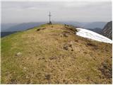
 | Gozd - Storžič (through southwest groove)
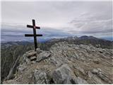
Storžič is a 2132 m high mountain located in the western part of the Kamink Savinja Alps. From the top with a cross there are beautiful views of ...
4 h 50 min |
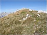
 | Planina Jezerca - Kalška gora (via planina Koren)
Kalška gora is located between Kalški greben and Kokrsko sedlo. From the top, which is covered with grass, there is a beautiful view towards the ...
4 h 35 min |
| Markova raven - Kalška gora (on marked path)
Kalška gora is located between Kalški greben and Kokrsko sedlo. From the top, which is covered with grass, there is a beautiful view towards the ...
5 h 30 min |
| Kokra (Roblek) - Kalška gora (via Kalce)
Kalška gora is located between Kalški greben and Kokrsko sedlo. From the top, which is covered with grass, there is a beautiful view towards the ...
4 h 30 min |
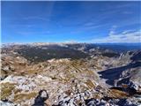
 | Planina Kuhinja - Krn (via jezero v Lužnici)
At 2244 m, Krn is the highest peak of the Krn Mountains, a mountain range that rises steeply above the central part of the Soča River. From the s...
4 h 45 min |
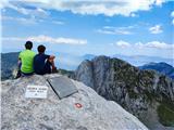
 | Planina Kuk - Tolminski Kuk
Tolminski Kuk is the highest peak of the Lower Bohinj Mountains. The summit, which has a registration box, offers a very nice view. From the top ...
4 h 30 min |
 | Ski hotel Vogel - Tolminski Kuk
Tolminski Kuk is the highest peak of the Lower Bohinj Mountains. The summit, which has a registration box, offers a very nice view. From the top ...
5 h 35 min |
 | Tolminske Ravne - Tolminski Kuk (via Dolina pod Ploščo)
Tolminski Kuk is the highest peak of the Lower Bohinj Mountains. The summit, which has a registration box, offers a very nice view. From the top ...
4 h 35 min |
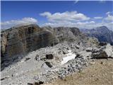
 | Aljažev dom v Vratih - Pogačnikov dom na Kriških podih (via Sovatna)
The hut is located on a panoramic hill in the Kriški Podi above Trenta. The hut, which is open in the summer season, also has a large winter room...
4 h 30 min |
 | Planina Blato - Zasavska koča na Prehodavcih (via Štapce)
Zasavska koča na Prehodavcih is located on a scenic peak above the Triglav Lakes Valley. The hut, which is open in the summer season, offers a be...
5 h 15 min |
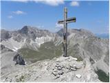
 | Aljažev dom v Vratih - Križ (via bivak na Rušju)
Križ is a 2140 m high mountain located north-east of the Kriški Podi. From the top, where there is a registration box with a stamp, you have a be...
4 h 30 min |
 | Ljubelj - Prešernova koča na Stolu (upper way)
Prešernova koča na Stolu, is located just a few metres below the summit of the 2198 m high Mali Stol. From the hut or the nearby Mali Stol, we ha...
4 h 45 min |
| Ljubelj - Prešernova koča na Stolu (via Vatelca or Skleda)
Prešernova koča na Stolu, is located just a few metres below the summit of the 2198 m high Mali Stol. From the hut or the nearby Mali Stol, we ha...
4 h 55 min |
 | Trate / Johannsenruhe - Prešernova koča na Stolu (via Celovška koča)
Prešernova koča na Stolu, is located just a few metres below the summit of the 2198 m high Mali Stol. From the hut or the nearby Mali Stol, we ha...
3 h 40 min |
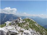
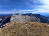
 | Kokra (Roblek) - Kalški greben
Kalški greben is 2224 m high and is the highest peak of the eponymous ridge. The summit, which has a registration box and a stamp, offers a beaut...
3 h 55 min |
 | The Kot Valley - Visoka Vrbanova špica (via Staničev dom)
Visoka Vrbanova špica, is located at the extreme south-western part of the ridge rising above the Kot and Vrata valleys, and higher up between th...
4 h 20 min |
 | Ravenska Kočna - Ledinski vrh (hunter's way)
The mountain is located above Jezersko, on the border with Austria. From the top there is a beautiful view towards the neighbouring Baba to the n...
3 h 30 min |
| Koča pod slapom Rinka - Ledinski vrh
The mountain is located above Jezersko, on the border with Austria. From the top there is a beautiful view towards the neighbouring Baba to the n...
3 h 30 min |
 | Velacher Kotschna/Belska Kočna - Ledinski vrh
The mountain is located above Jezersko, on the border with Austria. From the top there is a beautiful view towards the neighbouring Baba to the n...
3 h 45 min |
 | Matizovec - Veliko Kladivo
Veliko Kladivo is a 2094 m high peak in the Košuta Ridge, the longest Slovenian ridge. From the summit, which has a registration box and a stamp,...
3 h 20 min |
 | Planina Kuhinja - Batognica
Batognica is a 2164 m high mountain, which was affected by the Mine War during World War I. Remnants of the mine war between the Italians and the...
3 h 20 min |
| Koča na planini Kuhinja - Batognica
Batognica is a 2164 m high mountain, which was affected by the Mine War during World War I. Remnants of the mine war between the Italians and the...
3 h 15 min |
 | Bele Vode - Jerebica
Jerebica is a mountain located on the border between Slovenia and Itali, between Moznica and the Jezersko Valley. The summit, which has a registr...
3 h 30 min |
 | Planina Blato - Mala Zelnarica (via Štapce)
Mala Zelnarica is a 2310 m high peak located between the Triglav Lakes Valley and the Za Kopica Valley. The summit, which has a registration box ...
5 h 15 min |
 | Koča pod slapom Rinka - Velika (Koroška) Baba
Velika is a 2127 m high mountain on the border ridge above the Ravenská Kočna valley on the Slovenian side and above the Bela valley (Belska Kočn...
4 h 30 min |
| Ravenska Kočna - Velika (Koroška) Baba (on hunting path and over Jezersko sedlo)
Velika is a 2127 m high mountain on the border ridge above the Ravenská Kočna valley on the Slovenian side and above the Bela valley (Belska Kočn...
4 h 30 min |
 | Planina Kuk - Vrh nad Škrbino (direct way)
Vrh nad Škrbino is the easternmost two-thousandth peak in the ridge of the Lower Bohinj Mountains. From the top there is a very nice view of the ...
3 h 15 min |
| Tolminske Ravne - Vrh nad Škrbino (on mule track and direct way)
Vrh nad Škrbino is the easternmost two-thousandth peak in the ridge of the Lower Bohinj Mountains. From the top there is a very nice view of the ...
4 h |
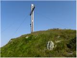
 | Weissensee - Eckwand (via Almspitz)
Eckwand is a 2221-metre peak in the Latschur Group. The grassy summit on which the cross stands offers a beautiful view of Gailtaler Alps, Carnic...
4 h 45 min |
 | Untere Valentinalm - Rauchkofel
To the north of Monte Coglians, the highest peak of Carnic Alps, is the 2460 m high Rauchkofel. From the top, where a cross and a signing box sta...
3 h 15 min |
| Untere Wolayeralm - Rauchkofel
To the north of Monte Coglians, the highest peak of Carnic Alps, is the 2460 m high Rauchkofel. From the top, where a cross and a signing box sta...
3 h 45 min |
| Rifugio Tolazzi - Rauchkofel
To the north of Monte Coglians, the highest peak of Carnic Alps, is the 2460 m high Rauchkofel. From the top, where a cross and a signing box sta...
3 h 15 min |
 | Raabtal - Monte Vancomun / Hochspitz
Monte Vancomun is a 2580 m high mountain located to the south of the Upper Zilj valley. From the top with a cross, you have a beautiful view of L...
3 h 15 min |
 | Planina Kuk - Zeleni vrh
Zeleni vrh is a 2052 m high mountain located east of the highest peak of the Lower Bohinj Mountains. The grassy peak, which descends precipitousl...
4 h 5 min |
| Ski hotel Vogel - Zeleni vrh
Zeleni vrh is a 2052 m high mountain located east of the highest peak of the Lower Bohinj Mountains. The grassy peak, which descends precipitousl...
5 h 10 min |
 | Tolminske Ravne - Zeleni vrh (via Dolina pod Ploščo)
Zeleni vrh is a 2052 m high mountain located east of the highest peak of the Lower Bohinj Mountains. The grassy peak, which descends precipitousl...
4 h 10 min |
 | Rifugio Pederü - Muntejela de Sennes
Muntejela de Sennes (Monte Sella di Sennes) is a 2,787-metre-high peak in the Fanes Sennes Prags Natural Park. The summit is located west of the ...
3 h 30 min |
 | Klammbrückl - Weittalspitze
Weittalspitze is a 2,539-metre-high peak in the Lienz Dolomites. The summit is located south of the mountain pasture Kerschbaumeralm. From the su...
3 h 30 min |
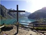 | Kesselfall - Höhenburg
Höhenburg is a 2108 metre high mountain in the Glockner mountain group in the High Tauern. It is located next to the Moserboden reservoir. From t...
3 h 50 min |
 | Sant'Uberto - Col Bechei
Col Bechei (also Col Becchei, Pareispitze in German, Monte Parei in Italian) is a 2,794-metre-high peak above the Valle di Fanes and Valle di Rud...
4 h 45 min |
| Rifugio Pederü - Col Bechei
Col Bechei (also Col Becchei, Pareispitze in German, Monte Parei in Italian) is a 2,794-metre-high peak above the Valle di Fanes and Valle di Rud...
3 h 55 min |
 | Weißenbach - Spitzegel / Negal (25d)
Spitzegel or. Negal (in Slovene) is a 2119 m high mountain in Gailtal Alps in Austria.The narrow ridge is a logical continuation of Dobrač / Dobr...
3 h 40 min |
 | Collina - Cima Ombladet (path 141)
Cima Ombladet is a 2255-metre-high mountain in Carnic Alps, east of Forni Avoltri. From the top of the hill, where there is a small cross, there ...
3 h 20 min |
 | Sant'Uberto - Bivacco Baccon Barborka
The Bivacco Baccon Barborka is a smaller bivouac with four beds. The bivouac is located next to the Furcia Rossa III peak, where you will see a l...
4 h 35 min |
| Rifugio Pederü - Bivacco Baccon Barborka
The Bivacco Baccon Barborka is a smaller bivouac with four beds. The bivouac is located next to the Furcia Rossa III peak, where you will see a l...
4 h 10 min |
 | Neustift im Stubaital - Hoher Burgstall (south path via Starkenburger Hütte)
Hoher Burgstall is one of the 7 classic Stubai Alps peaks, recognised by locals as outstanding in historical, touristic and aesthetic terms, whic...
4 h 15 min |
 | Tri studničky - Kriváň
Mount Kriváň is the first dominant peak of the High Tauern, seen from the west, and belongs to the Tatra National Park. It rises above the Liptov...
4 h |
 | Crno polje - Zelena glava
Zelena glava is the highest peak of mountain pasture Prenj, located in northern Herzegovina south of Konjica and north of Mostar. From the summit...
4 h |
 | Parkplatz Tappenkarweg - Weißgrubenkopf (Parkplatz Tappenkarweg - Weißgrubenkopf)
...
3 h 30 min |
| Koča pod slapom Rinka - Ledenik pod Skuto
...
4 h 10 min |