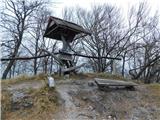
 | Trnovec - Polhograjska Grmada
Polhograjska Grmada is an 898 m high peak located in the heart of the Polhograjski Dolomiti. The summit, which has a registration box with a stam...
1 h 15 min |
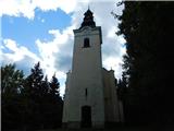
 | Legastja - Sveti Jakob
The Church of St James is located on a hill north of the village of Topol near Medvode. From the top, where there is a registration box with a st...
1 h 10 min |
 | Legastja - Sveti Jakob (north path)
The Church of St James is located on a hill north of the village of Topol near Medvode. From the top, where there is a registration box with a st...
1 h |
 | Rakovica - Sveti Jošt above Kranj
Sveti Jošt above Kranj, is a hill located to the west of the slightly lower Šmarjetna Gora. From the top, where the Church of St. Jošto and the J...
1 h 20 min |
 | Pševo - Sveti Jošt above Kranj (Sodarjeva pot, past the chapel)
Sveti Jošt above Kranj, is a hill located to the west of the slightly lower Šmarjetna Gora. From the top, where the Church of St. Jošto and the J...
50 min |
| Tičnica - Sveti Jošt above Kranj (Pot prijateljev Sv. Jošta, on stairs)
Sveti Jošt above Kranj, is a hill located to the west of the slightly lower Šmarjetna Gora. From the top, where the Church of St. Jošto and the J...
1 h 15 min |
| Tičnica - Sveti Jošt above Kranj (Pot prijateljev Sv. Jošta, na klopca)
Sveti Jošt above Kranj, is a hill located to the west of the slightly lower Šmarjetna Gora. From the top, where the Church of St. Jošto and the J...
1 h 15 min |
| Tičnica - Sveti Jošt above Kranj (Pot prijateljev Sv. Jošta, past the chapel)
Sveti Jošt above Kranj, is a hill located to the west of the slightly lower Šmarjetna Gora. From the top, where the Church of St. Jošto and the J...
1 h 20 min |
 | Trnovec - Osolnik (by road)
Osolnik is an 858 m high mountain located south of Škofja Loka and west of Medvode. From the top, where the Church of St. Mohor and Fortunatus st...
1 h 20 min |
 | Trnovec - Osolnik (via Mavški graben)
Osolnik is an 858 m high mountain located south of Škofja Loka and west of Medvode. From the top, where the Church of St. Mohor and Fortunatus st...
1 h 15 min |
| Trnovec - Osolnik (via Govejski graben)
Osolnik is an 858 m high mountain located south of Škofja Loka and west of Medvode. From the top, where the Church of St. Mohor and Fortunatus st...
1 h 15 min |
 | Krače - Zasavska Sveta gora
Zasavska Sveta gora is a popular excursion point located between Litija and Izlaki. From the top, where the parish church of the Nativity of the ...
1 h 15 min |
 | Slavkov dom na Golem brdu - Jeterbenk
Jeterbenk is a 774 m high peak located between Slavko's home at Gole Brdo and Katarina (Topol village). From the top, where there is a large cros...
1 h 15 min |
 | Žlebe - Jeterbenk (via Turnice)
Jeterbenk is a 774 m high peak located between Slavko's home at Gole Brdo and Katarina (Topol village). From the top, where there is a large cros...
1 h |
 | Žlebe - Jeterbenk (on ridge)
Jeterbenk is a 774 m high peak located between Slavko's home at Gole Brdo and Katarina (Topol village). From the top, where there is a large cros...
1 h 5 min |
 | Polhov Gradec (Blagajev grad) - Polhograjska Gora (Sveti Lovrenc)
Polhograjska Gora, also just Gora or Sveti Lovrenc, is an 824 m high hill located north-west of Polhov Gradec. From the top of the hill, where th...
1 h 5 min |
 | Polhov Gradec (Blagaj Castle) - Polhograjska Gora (Sveti Lovrenc) (via castle water catchment)
Polhograjska Gora, also just Gora or Sveti Lovrenc, is an 824 m high hill located north-west of Polhov Gradec. From the top of the hill, where th...
1 h 10 min |
| Polhov Gradec (Blagaj Castle) - Polhograjska Gora (Sveti Lovrenc) (by cart track)
Polhograjska Gora, also just Gora or Sveti Lovrenc, is an 824 m high hill located north-west of Polhov Gradec. From the top of the hill, where th...
1 h 15 min |
 | Vrzdenec - Kožljek
Kožljek is a 788 m high peak located to the west of Koreno, specifically above the village of Samotorica. From the top, where there are a few ben...
1 h 5 min |
 | Potoki - Ajdna
Ajdna is a peak with a beautiful view of Hochstuhl, Jelovica, Pokljuka and the Julian Alps. Part of the Gornjesavska valley between Žirovnica and...
1 h |
 | Krašnja - Limbarska gora
Limbarska gora is located north-east of Moravce. From the top there is a beautiful view of the surrounding peaks and in good weather you can also...
1 h 15 min |
 | Praprotno - Archangel Gabriel (Planica)
Planica is an 824 m high peak located north of Škofja Loka, between Krizna Gora and Planica. From the top, where the Church of St. Gabriel the Ar...
1 h 20 min |
 | Star maln - Koča na Planini nad Vrhniko
Planina above Vrhnika is for hers inhabitants something like Šmarna gora for inhabitants of Ljubljana. It is 733 metres high and is reachable fro...
1 h |
 | Kuren - Ulovka
Ulovka is the peak between Zaplana and the Shelter at Mountain pasture above Vrhnika. From the top, which is reached by ski lifts, there is a nic...
50 min |
 | Hotovlja - Bukov vrh (footpath)
Bukov vrh, on which the Church of the Sorrowful Mother of God stands, is located in the north-western part of the Polhograje hills. From the top ...
1 h |
 | Podgorje - Slavnik (steep path)
Slavnik is a scenic mountain rising south of Kozina and west of Podgorje. Podgorje is a village which is a suitable starting point for ascending ...
1 h 15 min |
 | Zazid - Kojnik
Kojnik is a partially vegetated peak located in the southern part of the Podgorje Karst near the Slovenian-Croatian border. From the top of the s...
1 h 20 min |
 | Begunje - Velika Špička (via Cemarovnik)
Velika Špička or Špičasto Stražišče is a peak located north of Slivnica. From the top, which has a registration box with a stamp, there is a beau...
1 h |
 | Begunje - Velika Špička
Velika Špička or Špičasto Stražišče is a peak located north of Slivnica. From the top, which has a registration box with a stamp, there is a beau...
1 h |
 | Širje - Dom v Gorah
The mountain lodge in Gora is located east of Hrastnik, just a few metres below the 786m-high peak on which the Church of St George stands. From ...
1 h 20 min |
| Krnice - Dom v Gorah
The mountain lodge in Gora is located east of Hrastnik, just a few metres below the 786m-high peak on which the Church of St George stands. From ...
1 h 5 min |
 | Marno - Dom v Gorah
The mountain lodge in Gora is located east of Hrastnik, just a few metres below the 786m-high peak on which the Church of St George stands. From ...
1 h 15 min |
 | Studeno - Gora (Sveti Lovrenc)
Gora, or Sveti Lovrenc, is a peak above Studeni. It is a village north of Postojna, which is also a good starting point for climbing to the top o...
1 h 5 min |
 | Gorenje - Gora (Sveti Lovrenc)
Gora, or Sveti Lovrenc, is a peak above Studeni. It is a village north of Postojna, which is also a good starting point for climbing to the top o...
1 h 15 min |
 | Sovodenj - Bevkov vrh (steep way)
Bevkov vrh, which is a point on the Slovenian mountain trail, is located between Cerkno and Spodnja Idrija. The summit is covered with forest and...
1 h 15 min |
 | Dobrič - Gora Oljka
Gora Oljka is a hill located east of Šmartno ob Paki. On the top stands the Church of the Holy Cross, which was built in the mid-18th century. Ju...
50 min |
 | Matke - Golava
Golava is a peak located north of Mrzlica. From the summit, on which a small bivouac (Blaž's bivouac) stands, there is a beautiful view towards t...
1 h 15 min |
 | Žička kartuzija - Skala
Skala is a viewpoint on the eastern part of Konjiška Gora. From the viewpoint, which has a table, bench and a registration box, there is a beauti...
1 h |
 | Mrzle doline - Sveti Peter
Sveti Peter is a partially vegetated peak in the Dry Krajina above the village of Dvor. On the top there is a small shelter (usually open on Sund...
1 h 15 min |
 | Legastja - Rog
The Rog is a 798 m high peak located above the village of Topole, just 10 minutes from St Catherine's Church. From the top of the hill, where a l...
1 h 15 min |
 | Tržič - Kamnek (Radetzky way)
Kamnek (Kamnik on maps, but also Kamnjek) is a scenic peak above Tržič....
1 h |
 | Tržič (Slap) - Kamnek (via Ride)
Kamnek (Kamnik on maps, but also Kamnjek) is a scenic peak above Tržič....
55 min |
 | Bločice - Križna gora
Križna gora is a partially overloked peak located above the village of Sveta Ana and Podlož. From the top of the hill on which the Church of the ...
1 h 15 min |
 | Podgora - Kamen vrh
Kamen vrh is a scenic peak located on the northern outskirts of Mala Gora. From the top, surrounded by low bushes, there is a beautiful view of p...
1 h |
 | Podpeč - Kamen vrh
Kamen vrh is a scenic peak located on the northern outskirts of Mala Gora. From the top, surrounded by low bushes, there is a beautiful view of p...
50 min |
 | Podgora - Grmada on Mala gora
Grmada (also Grmada nad Ortnek) is an 887 m high peak located above the village of Vrh pri Poljanah in the Mala Gora mountain range. Just a few m...
1 h 20 min |
 | Ortnek - Grmada on Mala gora
Grmada (also Grmada nad Ortnek) is an 887 m high peak located above the village of Vrh pri Poljanah in the Mala Gora mountain range. Just a few m...
1 h |
 | Steljnik - Stene svete Ane
Stene svete Ane is a vegetated peak located near the mountain hut at Sveti Anna on Mali gora. A small observation tower stands on the summit, whi...
1 h 20 min |
| Seljan - Stene svete Ane (gentle path)
Stene svete Ane is a vegetated peak located near the mountain hut at Sveti Anna on Mali gora. A small observation tower stands on the summit, whi...
1 h 5 min |
 | Col - Kovk
Kovk is a scenic peak located to the west of Cola, on a jagged ridge rising steeply above the Vipava valley. From the top with a cross, we have a...
1 h |
 | Zgornja Rečica (cerkev bl. Antona Martina Slomška) - Govško brdo
Govško brdo is an 811m high hill located west of the village of Huda jama above Laško. From the top of the hill, where the registration box and s...
1 h 15 min |
 | Adergas - Štefanja gora (via benches)
Štefanja gora on which the Church of St Stephen stands, is located above Cerkly in Gorenjska. Just 10 metres below the summit, the Pr'Mežnarju ex...
1 h |
 | Adergas - Štefanja gora (via šterna)
Štefanja gora on which the Church of St Stephen stands, is located above Cerkly in Gorenjska. Just 10 metres below the summit, the Pr'Mežnarju ex...
1 h |
 | Velesovo - Štefanja gora (via benches)
Štefanja gora on which the Church of St Stephen stands, is located above Cerkly in Gorenjska. Just 10 metres below the summit, the Pr'Mežnarju ex...
1 h 10 min |
 | Velesovo - Štefanja gora (via Šterna)
Štefanja gora on which the Church of St Stephen stands, is located above Cerkly in Gorenjska. Just 10 metres below the summit, the Pr'Mežnarju ex...
1 h 10 min |
 | Polhov Gradec (Božna) - Mala Grmada (via Setnica)
Mala Grmada is an 853 m high peak located south-west of the slightly higher Polhograjska Grmada. From the top, you have a beautiful view over the...
1 h 15 min |
 | Ljubljanica - Sveti Andrej (Planina above Horjul)
The Church of St Andrew is situated on a lookout hill just above the Mountain pasture above Horjul. The church, which was built in 1659, offers a...
1 h 15 min |
 | Brod - Rudnica
Rudnica is a scenic mountain located between the Lower and Upper Bohinj Valley. From the top, where there is a registration box with a stamp and ...
1 h 15 min |
| Savica - Rudnica
Rudnica is a scenic mountain located between the Lower and Upper Bohinj Valley. From the top, where there is a registration box with a stamp and ...
1 h 15 min |
 | Kropa - Sveti Primož in Felicijan (Jamnik)
The Church of St. Primož and Felicijan on Jamnik, is situated on a scenic grassy ridge rising between Kropa and Podblica. From the church or its ...
1 h 10 min |
 | Rovte - Sveti Primož in Felicijan (Jamnik)
The Church of St. Primož and Felicijan on Jamnik, is situated on a scenic grassy ridge rising between Kropa and Podblica. From the church or its ...
1 h 15 min |
 | Češnjica pri Kropi - Sveti Primož in Felicijan (Jamnik)
The Church of St. Primož and Felicijan on Jamnik, is situated on a scenic grassy ridge rising between Kropa and Podblica. From the church or its ...
1 h 15 min |
 | Hunting sports association Vinska Gora - Ramšakov vrh
Ramšakov vrh is the highest point of the circular route around Vinská Gora. On the 970 m high summit, besides the bench, there is a registration ...
1 h |
 | Prelska - Vinska gora
Vinska gora, marked on some maps as neighbouring Temnjak, is an 806 m high hill located north-west of Dobrnež and north-east of Vinská Gora. The ...
1 h 20 min |
 | Kolovrat - Reber
Reber is an 878 m high peak located south-west of Trojany. On the summit, which has a registration box with a registration book and a stamp, ther...
1 h |
 | Narin - Šilentabor
Šilentabor is a 751 m high peak located just above the village of the same name. From the top, near which there is also a bench and a registratio...
1 h |
 | Krvavi Potok - Veliko Gradišče
Veliko Gradišče is a 742 m high peak located south of the village of Lokev in the Karst and east of Kokoši. From the top, on which stands a concr...
1 h |
 | Bašelj - Gradišče (Pustinjak) (via Sveti Lovrenc)
Gradišče or Pustinjak (also Gradišče above Bašlje) is an 871-metre-high peak located above the Belica stream, which in turn is below the 2132-met...
1 h 15 min |
 | Velesovo - Apnišče (via Šterna)
Apnišče is a 740 m high mountain located between Možjanca and Štefanja gora. It is the highest point of the Šenčur municipality. There is a bench...
1 h 10 min |
 | Hunting cottage Budanje - Sončnica (Reber)
Sončnica is a paragliding airstrip on the outskirts of the Gora plateau or Reber Ridge. There are a few benches, an automatic weather station Kov...
1 h 10 min |
| Col - Sončnica (Reber)
Sončnica is a paragliding airstrip on the outskirts of the Gora plateau or Reber Ridge. There are a few benches, an automatic weather station Kov...
1 h 20 min |
 | Jereka - Vodnikov razglednik
Vodnikov razglednik is a 1017-metre high mountain located between Jereka and Koprivnik in Bohinj. From the top, where there is a large cross and ...
1 h 15 min |
 | Poljana - Volinjak (via Stovčnik)
Volinjak (misnamed Volinjek on some maps) is an 886-metre-high peak located between Mežica and Prevalje. From the top, where there is a registrat...
1 h 15 min |
| Leše - Volinjak (via Hermanko)
Volinjak (misnamed Volinjek on some maps) is an 886-metre-high peak located between Mežica and Prevalje. From the top, where there is a registrat...
1 h 5 min |
| Leše - Volinjak (via Prapar)
Volinjak (misnamed Volinjek on some maps) is an 886-metre-high peak located between Mežica and Prevalje. From the top, where there is a registrat...
1 h 5 min |
 | Mežica - Volinjak
Volinjak (misnamed Volinjek on some maps) is an 886-metre-high peak located between Mežica and Prevalje. From the top, where there is a registrat...
1 h 10 min |
 | Rebrca / Rechberg - Rokov vrh / Rochusberg (via Bukovnik)
Rokov vrh is an 880 m high peak (according to some data 817 m) located between the settlements of Suha / Zauchen, Rebrca / Rechberg and Podkraj /...
1 h |
 | Križe - Planica (Paragliding site Gozd)
Planica is a 926-metre-high peak located above the village of Gozd. From the top, where the JPK Kriška gora hut is located, we have a beautiful v...
1 h 20 min |
| Tržič - Planica (Paragliding site Gozd)
Planica is a 926-metre-high peak located above the village of Gozd. From the top, where the JPK Kriška gora hut is located, we have a beautiful v...
1 h 20 min |
 | Podjuna / Jaunstein - Gora sv. Eme (Junska gora) / Hemmaberg (umik zaprti poti)
Gora sv. Eme is located south of the village of Podjuna / Jaunstein. The Church of St. Emma (Hema) Krška stands on the top and the ruins of forme...
55 min |
| Globasnica / Globasnitz - Gora sv. Eme (Junska gora) / Hemmaberg
Gora sv. Eme is located south of the village of Podjuna / Jaunstein. The Church of St. Emma (Hema) Krška stands on the top and the ruins of forme...
55 min |
 | Škale - Lubela (via hunting lodge)
Lubela is a hill at Velenje, rising north above the Šaleška dolina and belonging to the Šentviška hills or the wider area of the Graška Gora.On t...
1 h 15 min |
 | Predgrad - Kozice
Kozice is a 741-metre-high peak with an RTV transmitter located above the left bank of the Kolpa River. From the lookout point on the southern pe...
1 h 15 min |
 | Zreče (cemetery) - Golek
Golek is a 769-metre-high peak located north-west of Zreče. At the top there is a registration box with a registration book, a stamp and a bench,...
1 h 15 min |
 | Stubenbergsee - Kulmkögerl (Kulmgipfel)
Kulmkögerl is an 866-metre-high peak located above Lake Stubenbergsee. A wooden cross and a registration box stand at the top....
1 h 20 min |
 | Škalske Cirkovce - Stropnik
...
1 h |
 | Škalske Cirkovce - Stropnica (čez Stropnik)
...
1 h 10 min |
 | Škalske Cirkovce - Stropnica
...
1 h |
 | Budaci - Velinac
...
1 h |
 | Radegunda (Žekovec) - Sveta Radegunda (Radegunda)
...
1 h 15 min |