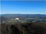
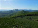
 | Loke - Sveta planina (Partizanski vrh)
Sveta planina, also Partizanski vrh, is a 1011 m high mountain located between Čemšeniška mountain pasture and Mrzlica. From the top, where a sma...
2 h 25 min |
 | Slovenske Konjice - Stolpnik (via castle)
At 1012 m, Stolpnik is the highest peak of the Konjiška Gora, a mountain range stretching south-west from Slovenske Konjice. A 25 m high lookout ...
2 h 15 min |
 | Žička kartuzija - Stolpnik (via Krniški rob)
At 1012 m, Stolpnik is the highest peak of the Konjiška Gora, a mountain range stretching south-west from Slovenske Konjice. A 25 m high lookout ...
2 h 30 min |
 | Žička kartuzija - Stolpnik (via Skala and Krniški rob)
At 1012 m, Stolpnik is the highest peak of the Konjiška Gora, a mountain range stretching south-west from Slovenske Konjice. A 25 m high lookout ...
3 h 15 min |
 | Žička kartuzija - Stolpnik (Žička kartuzija - Stolpnik - Črešnjice)
At 1012 m, Stolpnik is the highest peak of the Konjiška Gora, a mountain range stretching south-west from Slovenske Konjice. A 25 m high lookout ...
3 h 15 min |
 | Stranice - Stolpnik (via Grofov štant)
At 1012 m, Stolpnik is the highest peak of the Konjiška Gora, a mountain range stretching south-west from Slovenske Konjice. A 25 m high lookout ...
2 h 25 min |
 | Stranice - Stolpnik (via hunting cottage Štepih)
At 1012 m, Stolpnik is the highest peak of the Konjiška Gora, a mountain range stretching south-west from Slovenske Konjice. A 25 m high lookout ...
2 h 15 min |
| Spodnje Stranice (graves of hundred hostages) - Stolpnik (via Grofov štant)
At 1012 m, Stolpnik is the highest peak of the Konjiška Gora, a mountain range stretching south-west from Slovenske Konjice. A 25 m high lookout ...
2 h 10 min |
 | Frankolovo - Stolpnik
At 1012 m, Stolpnik is the highest peak of the Konjiška Gora, a mountain range stretching south-west from Slovenske Konjice. A 25 m high lookout ...
2 h 30 min |
 | Žička kartuzija - Stolpnik (čez Sojek in Vratca)
At 1012 m, Stolpnik is the highest peak of the Konjiška Gora, a mountain range stretching south-west from Slovenske Konjice. A 25 m high lookout ...
2 h 10 min |
| Žička kartuzija - Stolpnik (mimo Treh križev in čez Vratca)
At 1012 m, Stolpnik is the highest peak of the Konjiška Gora, a mountain range stretching south-west from Slovenske Konjice. A 25 m high lookout ...
2 h 15 min |
 | ŽP Buzet - Žbevnica (po IPP)
Žbevnica is a 1014 m high peak located above the village of Brest, on the Slovenian-Croatian border. The summit offers a beautiful view of Sloven...
3 h |
 | ŽP Buzet - Žbevnica (položna pot)
Žbevnica is a 1014 m high peak located above the village of Brest, on the Slovenian-Croatian border. The summit offers a beautiful view of Sloven...
3 h 15 min |
 | Matrafüred - Kékestető (red path via Peresberc in Negyeshatar)
Matra is a mountain range located 70 km east of Budapest. The two highest peaks in Hungary are Kékestető, which is the highest peak in Hungary at...
2 h 45 min |
 | Matrafüred - Kékestető (zelena pot)
Matra is a mountain range located 70 km east of Budapest. The two highest peaks in Hungary are Kékestető, which is the highest peak in Hungary at...
2 h 15 min |
 | Bistriški jarek (Verdinek) - Bricnik
Bricnik is a 1017-metre-high peak located in the Kozjak Mountains, above Muta. On the top, which is covered by forest, there is a registration bo...
3 h 10 min |
 | Radlje ob Dravi - Bricnik
Bricnik is a 1017-metre-high peak located in the Kozjak Mountains, above Muta. On the top, which is covered by forest, there is a registration bo...
2 h 30 min |
| Radlje ob Dravi - Bricnik (via Zavetišče Onuk - Glavar)
Bricnik is a 1017-metre-high peak located in the Kozjak Mountains, above Muta. On the top, which is covered by forest, there is a registration bo...
2 h 55 min |
| Dolina Radeljskega potoka (Razdevšek) - Bricnik
Bricnik is a 1017-metre-high peak located in the Kozjak Mountains, above Muta. On the top, which is covered by forest, there is a registration bo...
2 h 20 min |
| Dolina Radeljskega potoka (Razdevšek) - Bricnik (via Zavetišče Onuk - Glavar)
Bricnik is a 1017-metre-high peak located in the Kozjak Mountains, above Muta. On the top, which is covered by forest, there is a registration bo...
2 h 45 min |
 | Dravograd lake - Šteharski vrh (Šteharnikov vrh)
Šteharski or Šteharnikov vrh, also Črneška gora, is a 1018-metre-high mountain located in the south-eastern part of Strojna, a mountain range bet...
2 h 15 min |
 | Ernejčkov graben - Pasja ravan
Pasja ravan is the second highest peak in the Polhograje Hills. A few decades ago, at 1029 m, it was the highest peak, but the Yugoslav army flat...
3 h 15 min |
 | Polhov Gradec - Tošč (via Grmada)
Tošč, which became the highest peak of Polhograjsko hribovje decades ago when Pasja ravan was lowered by 9 m by the Yugoslav army, is located nor...
2 h 30 min |
 | Gabrje - Tošč
Tošč, which became the highest peak of Polhograjsko hribovje decades ago when Pasja ravan was lowered by 9 m by the Yugoslav army, is located nor...
3 h 5 min |
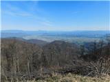
 | Podgorje ob Sevnični (Kurja vas) - Veliki Javornik (Bohor)
Veliki Javornik is the highest peak of Bohor at 1023m. Although the peak is unspoilt and there are no higher hills far around, there is no view f...
2 h 40 min |
 | Škofja Loka (Vincarje) - Lubnik (ridge path)
Lubnik is a 1025 m high mountain rising steeply to the west of Škofja Loka. From the summit, on which the mountain lodge stands, you can enjoy a ...
2 h 15 min |
 | Škofja Loka - Lubnik (via Stari grad)
Lubnik is a 1025 m high mountain rising steeply to the west of Škofja Loka. From the summit, on which the mountain lodge stands, you can enjoy a ...
2 h 15 min |
 | Praprotno - Lubnik
Lubnik is a 1025 m high mountain rising steeply to the west of Škofja Loka. From the summit, on which the mountain lodge stands, you can enjoy a ...
2 h 15 min |
| Poljane nad Škofjo Loko - Lubnik (via Gabrška gora)
Lubnik is a 1025 m high mountain rising steeply to the west of Škofja Loka. From the summit, on which the mountain lodge stands, you can enjoy a ...
3 h 45 min |
 | Hotavlje - Ermanovec (via Slajka)
Ermanovec is a 1026 m high peak located between Cerkno and Gorenjska vasja, specifically above Sovodnje and Trebija. Just a few steps away from t...
2 h 40 min |
 | Dolenji Novaki (Pod Kovkom) - Ermanovec
Ermanovec is a 1026 m high peak located between Cerkno and Gorenjska vasja, specifically above Sovodnje and Trebija. Just a few steps away from t...
3 h 15 min |
 | Matavun - Vremščica
Vremščica is a mountain chain, stretching between Senožeče, Pivka and Divača. The highest top is also called Vremščica and the view from it is am...
3 h 15 min |
| Famlje - Vremščica
Vremščica is a mountain chain, stretching between Senožeče, Pivka and Divača. The highest top is also called Vremščica and the view from it is am...
2 h 30 min |
 | Hrpelje - Slavnik
Slavnik is a scenic mountain rising south of Kozina and west of Podgorje. Podgorje is a village which is a suitable starting point for ascending ...
3 h 30 min |
 | Skadanščina - Slavnik (via Mala Vrata)
Slavnik is a scenic mountain rising south of Kozina and west of Podgorje. Podgorje is a village which is a suitable starting point for ascending ...
3 h |
 | Vrtovin - Mala gora
Mala gora is a plateau on the slope of the Chavn. A hut is located at an altitude of 1034 metres. Mala gora is known for its flowers, which are u...
2 h 15 min |
 | Vrčice - Mirna gora (via Škrilj)
Mirna gora is a 1047 m high, forested peak located on the south-eastern edge of the Kočevje Horn. The summit, which has a registration box and a ...
2 h 10 min |
| Vrčice - Mirna gora (via Planina)
Mirna gora is a 1047 m high, forested peak located on the south-eastern edge of the Kočevje Horn. The summit, which has a registration box and a ...
2 h 10 min |
 | Rein - Mühlbacher Kogel (Hunting path / Jägersteig)
Mühlbacher Kogel is a 1050m high mountain in the western part of the Graz mountain range in Styria, Austria. It is located above the Mühlbacher H...
2 h 10 min |
 | Rein - Mühlbacher Kogel (via Hochstein)
Mühlbacher Kogel is a 1050m high mountain in the western part of the Graz mountain range in Styria, Austria. It is located above the Mühlbacher H...
2 h 30 min |
 | Kopačnica - Bevkov vrh
Bevkov vrh, which is a point on the Slovenian mountain trail, is located between Cerkno and Spodnja Idrija. The summit is covered with forest and...
3 h 40 min |
 | Radlje ob Dravi - Kapunar / Kapunerkogel
Kapunar is a 1051 m high peak above Radlje ob Dravi. Just below the peak is an old caravan and border guardhouse, which is now used by radio amat...
2 h 15 min |
 | Radlje ob Dravi - Kapunar / Kapunerkogel (via Župank)
Kapunar is a 1051 m high peak above Radlje ob Dravi. Just below the peak is an old caravan and border guardhouse, which is now used by radio amat...
2 h 30 min |
| Radlje ob Dravi - Kapunar / Kapunerkogel (via old castle)
Kapunar is a 1051 m high peak above Radlje ob Dravi. Just below the peak is an old caravan and border guardhouse, which is now used by radio amat...
2 h 30 min |
 | Slovenska vas - Ledenik
At 1072 metres, Ledenik is the highest peak of Stojna, a forested ridge located between Kočevje and Kočevsko Rijeka. On the summit there is a reg...
3 h 15 min |
| Kočevje - Ledenik
At 1072 metres, Ledenik is the highest peak of Stojna, a forested ridge located between Kočevje and Kočevsko Rijeka. On the summit there is a reg...
2 h 15 min |
 | Kokarje (ŠRC Laze) - Tolsti vrh (Dobrovlje) (via Dom na Farbanci)
Tolsti vrh is, together with Šentjoški vrh (1077m), the highest peak of the Dobrovelj Plateau. The view from the summit, which has a registration...
3 h 15 min |
| Potok (Mostni graben) - Tolsti vrh (Dobrovlje) (via Dom na Farbanci)
Tolsti vrh is, together with Šentjoški vrh (1077m), the highest peak of the Dobrovelj Plateau. The view from the summit, which has a registration...
2 h 50 min |
 | Matke - Homič (mimo Kočeta in po gozdni vlaki)
...
2 h 25 min |
| Matke - Homič (mimo Kočeta in čez Kriško planino)
...
2 h 35 min |
 | Zgornja Rečica (cerkev bl. Antona Martina Slomška) - Gozdnik
Gozdnik is a hill rising steeply above the village of Zabukovica. There is no view from the top, due to the forest, but there is a bivouac on it,...
3 h 25 min |
 | Pongrac (grobišče talcev) - Gozdnik (mimo Malega Gozdnika)
Gozdnik is a hill rising steeply above the village of Zabukovica. There is no view from the top, due to the forest, but there is a bivouac on it,...
2 h 5 min |
 | Slovenska vas - Sveta Trojica
Sveta Trojica is a scenic peak located south-west of Javorniki. From the top, where the ruins of the former church are well preserved, you can en...
2 h 15 min |
 | Preserje - Krim
Krim is a 1107 m high mountain rising south of the Ljubljana Marshes. From the top of the mountain, where the mountain lodge and a number of tran...
2 h 20 min |
 | Dom v Iškem Vintgarju - Krim
Krim is a 1107 m high mountain rising south of the Ljubljana Marshes. From the top of the mountain, where the mountain lodge and a number of tran...
2 h 15 min |
 | Dolenja Brezovica - Krim
Krim is a 1107 m high mountain rising south of the Ljubljana Marshes. From the top of the mountain, where the mountain lodge and a number of tran...
2 h 10 min |
 | Iška - Krim
Krim is a 1107 m high mountain rising south of the Ljubljana Marshes. From the top of the mountain, where the mountain lodge and a number of tran...
2 h 10 min |
 | Marija Reka (Strgar) - Mrzlica (stalno zaprta pot)
Mrzlica has become an extremely popular excursion point in the last few years, especially for visitors from the Savinjska Valley and Zasavje. At ...
2 h 30 min |
 | Matke - Mrzlica (via Počivalnik)
Mrzlica has become an extremely popular excursion point in the last few years, especially for visitors from the Savinjska Valley and Zasavje. At ...
2 h 30 min |
 | Matke - Mrzlica (mimo Kočeta in po gozdni vlaki)
Mrzlica has become an extremely popular excursion point in the last few years, especially for visitors from the Savinjska Valley and Zasavje. At ...
2 h 40 min |
| Matke - Mrzlica (mimo Kočeta in čez Kriško planino)
Mrzlica has become an extremely popular excursion point in the last few years, especially for visitors from the Savinjska Valley and Zasavje. At ...
2 h 50 min |
 | Rakitnica - Bela stena
Bela stena (also just Stene) is a lookout point located west of Dolenje vas in the Ribnica valley, specifically above the village of Zadolje. Fro...
2 h 10 min |
 | Selski most - Babji zob (via Kupljenik)
Babji zob is a lookout point above the village of Kupljenik near Bled. The precipitous peak, which has a registration box, has a beautiful view o...
2 h 40 min |
 | Log - Mariborski razglednik (Cigelnica)
Mariborski razglednik) is a 1147 m high peak located next to the Maribor Pohorje ski resort. A lookout tower stands at the top, offering a beauti...
2 h 50 min |
| Pivola (Reka) - Mariborski razglednik (Cigelnica) (via Petkovo sedlo)
Mariborski razglednik) is a 1147 m high peak located next to the Maribor Pohorje ski resort. A lookout tower stands at the top, offering a beauti...
2 h 40 min |
 | Srednja Kanomlja - Hudournik
Hudournik is a 1148 m high peak located on the northern edge of the Vojskar plateau, a plateau situated between the valleys of the Idrijca, Kanom...
3 h 45 min |
 | Rovte - Bela peč (Podbliška gora)
Bela peč is located on the edge of Jelovica above the village of Podblica. From the top of the cliff we have a beautiful view of the village, the...
2 h 45 min |
 | Slovenj Gradec - Kremžarjev vrh
Kremžarjev vrh is the westernmost millennium on Pohorje. It is located north-east of Slovenj Gradec. There is no view from the summit, which has ...
2 h 15 min |
 | Log - Ledinekov kogel
Ledinekov kogel is a 1182 m high peak located north of Maribor hut. Just below the summit is a fenced area with a radar tower....
2 h 40 min |
 | Pivola (Reka) - Ledinekov kogel (vzhodna pot)
Ledinekov kogel is a 1182 m high peak located north of Maribor hut. Just below the summit is a fenced area with a radar tower....
2 h 40 min |
| Pivola (Reka) - Ledinekov kogel (zahodna pot)
Ledinekov kogel is a 1182 m high peak located north of Maribor hut. Just below the summit is a fenced area with a radar tower....
2 h 45 min |
 | Bezgovica - Cerk
At 1192 m, Cerk is the highest peak of Borovška Gora, a mountain range located between the Kolpa River valley and Goteniškje Snežnik. From the to...
2 h 55 min |
 | Trojane - Črni vrh (Čemšeniška planina)
Črni vrh is the highest peak of Čemšeniška mountain pasture and with a height of 1204 m it is the second highest peak in the Posavje - Zasavje hi...
2 h 45 min |
| Jelševica - Črni vrh (Čemšeniška planina)
Črni vrh is the highest peak of Čemšeniška mountain pasture and with a height of 1204 m it is the second highest peak in the Posavje - Zasavje hi...
2 h 45 min |
 | Dolina Zaplaninščice - Črni vrh (Čemšeniška planina)
Črni vrh is the highest peak of Čemšeniška mountain pasture and with a height of 1204 m it is the second highest peak in the Posavje - Zasavje hi...
2 h 30 min |
 | Loke - Črni vrh (Čemšeniška planina) (via Zajčeva koča)
Črni vrh is the highest peak of Čemšeniška mountain pasture and with a height of 1204 m it is the second highest peak in the Posavje - Zasavje hi...
3 h 35 min |
 | Kosmadei - Zastano (Samos) (no. 11 / 10)
Zastano (Greek: Ζάστανο), also known as Zestani (Greek: Ζεστάνι), with an elevation of 1206 meters, is the second-highest mountain on the Greek i...
3 h 10 min |
 | Laufnitzdorf - Schiffall
...
2 h 15 min |
 | Rakitnica - Rezinski vrh
Rezinski vrh is a 1231 m high mountain located in the middle of the vast forests of the Great Mountains. The summit, which has a registration box...
2 h 40 min |
 | Vrtovin - Kucelj na Čavnu
Kucelj is located on the southern slopes of Trnovo Forest, north-west of the Vipava valley. From the uncultivated summit on which the cross stand...
2 h 15 min |
 | Vrtovin - Kucelj na Čavnu (via Koča na Mali gori)
Kucelj is located on the southern slopes of Trnovo Forest, north-west of the Vipava valley. From the uncultivated summit on which the cross stand...
3 h |
 | Vitovlje - Veliki Rob
Veliki Rob is a scenic peak located between Kuclje (1237m) and Čavno (1185m). From the summit on which the cross is located, there is a beautiful...
3 h |
 | Vrtovin - Veliki Rob
Veliki Rob is a scenic peak located between Kuclje (1237m) and Čavno (1185m). From the summit on which the cross is located, there is a beautiful...
2 h 50 min |
| Vitovlje - Veliki Rob (via Vitovlje Lake and over Sekulak)
Veliki Rob is a scenic peak located between Kuclje (1237m) and Čavno (1185m). From the summit on which the cross is located, there is a beautiful...
3 h 10 min |
 | Frohnleiten - Hochtrötsch (Trötsch)
...
2 h 15 min |
 | Razdrto - Vojkova koča na Nanosu (gentle path)
Vojkova koča is located on the southern edge of the Nanoše plateau, close to Pleše, a peak that is clearly visible from the motorway. From the hu...
2 h 20 min |
 | Rakitnica - Turn
At 1254 m, Turn is the highest peak of the 14 km-long Velika Gora, a plateau rising between Ribnica polje and Liška Potok. The summit, which has ...
3 h |
 | Vitanje - Basališče (Paški Kozjak)
Basališče is the highest peak of Paško Kozjak. There is a bench and a registration box at the top. Due to the forest, there is no view....
2 h 30 min |
 | Spodnja Kokra - Potoška gora
The forested peak is located above Preddvor between Javorov vrh and the Iskra mountain lodge on Jakob. The summit has a bench and a registration ...
2 h 5 min |
 | Gotenica - Goteniški Snežnik
At 1289m, Goteniški Snežnik is the highest peak of Goteniška Gora. As the summit is covered by forest, the view from the summit is rather limited...
2 h 45 min |
| Kočevska Reka - Goteniški Snežnik
At 1289m, Goteniški Snežnik is the highest peak of Goteniška Gora. As the summit is covered by forest, the view from the summit is rather limited...
2 h 45 min |
 | Zlatten - Hochanger
...
2 h 30 min |
 | Trdnjava Kluže - Kota 1313
Kota 1313 was the location of the Austro-Hungarian artillery observation post during the First World War. From position 1313, which is located in...
2 h 20 min |
 | Ljubenske Rastke - Bezovec
Bezovec is a lesser known peak located in the Smrekov Mountains. From the top of the peak, where the hunting observatory stands, we have a beauti...
2 h 15 min |
 | Jesenice (Ukova) - Španov vrh (Čez sedem grabnov)
Španov vrh is a 1334m high mountain located between Javorniški Rovt and Mountain pasture below Golica. From the top, reached by the cable car of ...
2 h 30 min |
 | Činžat - Klopni vrh (northern path)
Klopni vrh encloses the lower lying extensive plateau in the eastern Pohorje Mountains from the north-west. The area of the horizontal section at...
2 h 45 min |
| Činžat - Klopni vrh (eastern path)
Klopni vrh encloses the lower lying extensive plateau in the eastern Pohorje Mountains from the north-west. The area of the horizontal section at...
2 h 45 min |
| Lovrenc na Pohorju - Klopni vrh (via Spodnji trg and on northern path)
Klopni vrh encloses the lower lying extensive plateau in the eastern Pohorje Mountains from the north-west. The area of the horizontal section at...
3 h 5 min |
| Lovrenc na Pohorju - Klopni vrh (via Spodnji trg and on eastern path)
Klopni vrh encloses the lower lying extensive plateau in the eastern Pohorje Mountains from the north-west. The area of the horizontal section at...
3 h 5 min |
| Lovrenc na Pohorju - Klopni vrh (via Zgornji trg and on northern path)
Klopni vrh encloses the lower lying extensive plateau in the eastern Pohorje Mountains from the north-west. The area of the horizontal section at...
2 h 30 min |
| Lovrenc na Pohorju - Klopni vrh (via Zgornji trg and on eastern path)
Klopni vrh encloses the lower lying extensive plateau in the eastern Pohorje Mountains from the north-west. The area of the horizontal section at...
2 h 30 min |
 | Oplotnica - Veliki vrh (on Pohorje)
Veliki vrh is a 1344-metre-high peak located above the RTC Jakec - Trije kralji ski resort. The highest point of the peak is located in the fores...
3 h 15 min |
 | Log - Žigartov vrh
At 1346m, Žigartov vrh is the highest peak in the eastern part of Pohorje. An "observation" tower used to stand on the summit, but was erected on...
3 h 35 min |
 | Vrtovin - Veliki Modrasovec
Veliki Modrasovec is located in the southern part of the Trnovo Forest near Predmeja. On the top of the hill is an old military building which yo...
3 h 5 min |
 | Planina Polog - Mrzli vrh above Planina Pretovč
Mrzli vrh is a well-known World War I battlefield. Today, the summit is known as an open-air museum, where you can see numerous caverns, trenches...
2 h 45 min |
 | Bistriški jarek (border crossing Muta) - Kozji vrh (at Košenjak)
Kozji vrh is a 1383-metre-high peak located above Pernice, and its height makes it the highest peak in the municipality of Muta....
2 h 50 min |
| Bistriški jarek (Glasbeni dom) - Kozji vrh (at Košenjak)
Kozji vrh is a 1383-metre-high peak located above Pernice, and its height makes it the highest peak in the municipality of Muta....
2 h 45 min |
| Muta (Zgornja Muta) - Kozji vrh (at Košenjak)
Kozji vrh is a 1383-metre-high peak located above Pernice, and its height makes it the highest peak in the municipality of Muta....
3 h 45 min |
 | Zali Log - Koprivnik
Koprivnik is a 1393 m high mountain located between Blegoš and Mladi vrh. The view from the summit, which has a registration box and a stamp, is ...
2 h 45 min |
 | Dolenji Novaki - Medrce
Medrce is a 1410 m high peak located between Porezno and Hum. From the top, where the old bunker is located, we have a beautiful view of Kojca, P...
3 h 15 min |
 | Gornji Grad - Lepenatka (via Kal)
Lepenatka is a grassy peak located south of the 1557 m high Rogatec. From the top, which has a registration box and a stamp, we have a beautiful ...
3 h |
 | Gornji Grad - Lepenatka (on ridge)
Lepenatka is a grassy peak located south of the 1557 m high Rogatec. From the top, which has a registration box and a stamp, we have a beautiful ...
3 h |
 | Spodnja Kokra - Javorov vrh
Javorov vrh (also Javorjev vrh according to some records) is a 1434 m high mountain located northeast of Preddvor. From the top, which has a regi...
2 h 20 min |
 | Potoče - Javorov vrh (via Potoška gora)
Javorov vrh (also Javorjev vrh according to some records) is a 1434 m high mountain located northeast of Preddvor. From the top, which has a regi...
2 h 45 min |
| Potoče - Javorov vrh (direct way)
Javorov vrh (also Javorjev vrh according to some records) is a 1434 m high mountain located northeast of Preddvor. From the top, which has a regi...
2 h 30 min |
 | Mače - Javorov vrh (Mačenska pot)
Javorov vrh (also Javorjev vrh according to some records) is a 1434 m high mountain located northeast of Preddvor. From the top, which has a regi...
2 h 50 min |
| Mače - Javorov vrh (via Kozjek)
Javorov vrh (also Javorjev vrh according to some records) is a 1434 m high mountain located northeast of Preddvor. From the top, which has a regi...
3 h |
 | Podbrdo - Kobla
The peak is located in the Lower Bohinj Mountains between Črna prst and Soriška mountain pasture. Just below the peak is a railway tunnel connect...
3 h |
 | Gornji Grad - Špic (via Semprimožnik)
Špic is a 1499 m high peak located in the immediate vicinity of the Doma na Menini mountain pasture. From the summit, next to which the transmitt...
3 h 15 min |
 | Gornji Grad - Vivodnik (via Semprimožnik and Ovčji stan)
At 1508 m, Vivodnik is the highest peak of the Menina mountain pasture, a plateau rising south of Gornji Grad. From the top, where there is a sma...
3 h 30 min |
 | Golice - Vivodnik
At 1508 m, Vivodnik is the highest peak of the Menina mountain pasture, a plateau rising south of Gornji Grad. From the top, where there is a sma...
2 h 45 min |
 | Podbrdo - Krevl
Krevl is a 1515 m high peak located to the south of the Kobla ski area, more precisely between Koble Peak and Kravje Črna Gora. From the summit, ...
3 h 15 min |
 | Bohinjska Bistrica - Krevl (via Planina za Črno goro)
Krevl is a 1515 m high peak located to the south of the Kobla ski area, more precisely between Koble Peak and Kravje Črna Gora. From the summit, ...
2 h 55 min |