 | Črni Kal - Blegoš (by road, via hut)
Blegoš is a 1562 m high mountain located between Selška and Poljane Sora. From the grassy summit, on which there is a stamp and a registration bo...
1 h 30 min |
 | Črni Kal - Blegoš (direct way)
Blegoš is a 1562 m high mountain located between Selška and Poljane Sora. From the grassy summit, on which there is a stamp and a registration bo...
1 h 10 min |
 | Črni kal - Blegoš (via Prva ravan)
Blegoš is a 1562 m high mountain located between Selška and Poljane Sora. From the grassy summit, on which there is a stamp and a registration bo...
1 h 20 min |
 | Mesnice - Krim (by road)
Krim is a 1107 m high mountain rising south of the Ljubljana Marshes. From the top of the mountain, where the mountain lodge and a number of tran...
1 h 50 min |
 | Rakitna - Krim
Krim is a 1107 m high mountain rising south of the Ljubljana Marshes. From the top of the mountain, where the mountain lodge and a number of tran...
2 h |
 | Polharski dom Krim - Krim
Krim is a 1107 m high mountain rising south of the Ljubljana Marshes. From the top of the mountain, where the mountain lodge and a number of tran...
1 h 35 min |
 | Grahovo - Slivnica
Slivnica is a 1114 m high peak located north of Cerknica polje. The view from the summit, where the entry box is located, is rather limited due t...
1 h 15 min |
 | Radlek - Slivnica
Slivnica is a 1114 m high peak located north of Cerknica polje. The view from the summit, where the entry box is located, is rather limited due t...
1 h 20 min |
 | Volovljek - Kranjska reber
Kranjska reber or Peak Kašna planina (1435 m) is a volcanic mountain. From the top, where the registration box with the stamp is located, we have...
1 h 20 min |
 | Črnivec - Kranjska reber
Kranjska reber or Peak Kašna planina (1435 m) is a volcanic mountain. From the top, where the registration box with the stamp is located, we have...
1 h 30 min |
 | Korensko sedlo - Ofen/Peč
Peč (also Tromeja), in Italian Monte Forno and in German Dreiländereck or Ofen, is a 1508 m high peak located on the tri-border between Slovenia,...
2 h |
 | Korensko sedlo - Ofen/Peč (on marked path)
Peč (also Tromeja), in Italian Monte Forno and in German Dreiländereck or Ofen, is a 1508 m high peak located on the tri-border between Slovenia,...
2 h |
 | Dom pod Storžičem - Bela peč
The mountain, which is known mainly by climbers, is located north of Storžič on the slopes of Konjščice. From the top there is a beautiful view o...
2 h |
 | Na kopiš - Bela peč (via Spodnja and Zgornja Konjščica)
The mountain, which is known mainly by climbers, is located north of Storžič on the slopes of Konjščice. From the top there is a beautiful view o...
2 h |
 | Javorje - Stari vrh (via Koča na Starem vrhu)
Stari vrh is a 1217 m high mountain located above the ski resort of the same name. There is no view from the summit itself due to the forest, but...
1 h 35 min |
 | Javorje - Stari vrh (via Prehodi)
Stari vrh is a 1217 m high mountain located above the ski resort of the same name. There is no view from the summit itself due to the forest, but...
1 h 30 min |
 | Zgornja Sorica - Dravh
Dravh is a 1547 m high peak located between Sorica and Soriška mountain pasture. From the uncultivated summit, we have a beautiful view of Škofje...
1 h 30 min |
 | Zgornja Sorica - Lajnar
Lajnar is a 1549 m high mountain located north of Soriška mountain pasture. From the top, which is also the highest point of the ski resort, we h...
1 h 40 min |
 | Hunting cottage Vojkovo - Vojkova koča na Nanosu
Vojkova koča is located on the southern edge of the Nanoše plateau, close to Pleše, a peak that is clearly visible from the motorway. From the hu...
1 h 45 min |
 | Furlanovo zavetišče pri Abramu - Vojkova koča na Nanosu
Vojkova koča is located on the southern edge of the Nanoše plateau, close to Pleše, a peak that is clearly visible from the motorway. From the hu...
2 h |
 | Krnica - Kucelj na Čavnu (via Veliki Rob)
Kucelj is located on the southern slopes of Trnovo Forest, north-west of the Vipava valley. From the uncultivated summit on which the cross stand...
1 h 40 min |
 | Predmeja - Mali Golak
Mali Golak is the highest of the Golaks. It was named not because it was the smallest but because it had the smallest mountain pasture. On the ma...
2 h |
 | Mala Lazna - Mali Golak
Mali Golak is the highest of the Golaks. It was named not because it was the smallest but because it had the smallest mountain pasture. On the ma...
1 h 25 min |
 | Kupljenik - Babji zob
Babji zob is a lookout point above the village of Kupljenik near Bled. The precipitous peak, which has a registration box, has a beautiful view o...
1 h 30 min |
 | Kozarnice - Srednji Golak (via Mali Golak)
Srednji Golak is located between Mali and Veliki Golak on the plateau of the Trnovo Forest above Predmeja. The summit is covered with dwarf pines...
1 h 50 min |
 | Lokve - Poldanovec
Poldanovec is located in Govce on the northern edge of Trnovo plateau. Govci are quickly rising above Gorenje Trebuše valley. Poldanovec is not t...
1 h 30 min |
 | Turški klanec - Mrzovec
Mrzovec is the most expressing peak in heart of Trnovo plateau. His position offers us great view, but is also limited with high trees. Thats why...
1 h 30 min |
 | Podmeja - Mrzlica
Mrzlica has become an extremely popular excursion point in the last few years, especially for visitors from the Savinjska Valley and Zasavje. At ...
1 h 15 min |
 | Podmeja - Mrzlica
Mrzlica has become an extremely popular excursion point in the last few years, especially for visitors from the Savinjska Valley and Zasavje. At ...
1 h 15 min |
 | Dom na Paškem Kozjaku - Basališče (Paški Kozjak)
Basališče is the highest peak of Paško Kozjak. There is a bench and a registration box at the top. Due to the forest, there is no view....
2 h |
 | St. John the Baptist on Ojstrica - Huhnerkogel/Košenjak
Huhnerkogel lies north of Dravograd and the River Drava on the border with neighbouring Austria. Huhnerkogel is accessible on foot or by car from...
1 h 30 min |
 | St. John the Baptist on Ojstrica - Huhnerkogel/Košenjak (via Bivak Piramida)
Huhnerkogel lies north of Dravograd and the River Drava on the border with neighbouring Austria. Huhnerkogel is accessible on foot or by car from...
2 h |
 | Jezero Sobote / Stausee Soboth - Huhnerkogel/Košenjak (po označeni poti)
Huhnerkogel lies north of Dravograd and the River Drava on the border with neighbouring Austria. Huhnerkogel is accessible on foot or by car from...
2 h |
 | Avsa - Mrzli vrh (on Matajur) (old path)
Mrzli vrh is a 1358-metre high peak located in the Matajur Mountains. From the top, where there is a viewing platform and a registration box with...
1 h 25 min |
 | Plajberški graben / Bleiberger Graben - Sinacher Gupf / Psinski vrh
Sinacher Gupf (on maps we mostly see the name Psinski vrh) / Sinacher Gupf is a peak located north of the main chain Karawanks, more precisely no...
1 h 35 min |
 | Strugarjach / Strugarje - Sinacher Gupf / Psinski vrh
Sinacher Gupf (on maps we mostly see the name Psinski vrh) / Sinacher Gupf is a peak located north of the main chain Karawanks, more precisely no...
1 h 30 min |
 | Čemšenik - Črni vrh (Čemšeniška planina)
Črni vrh is the highest peak of Čemšeniška mountain pasture and with a height of 1204 m it is the second highest peak in the Posavje - Zasavje hi...
1 h 30 min |
 | Planinski dom Vrhe - Črni vrh (Čemšeniška planina)
Črni vrh is the highest peak of Čemšeniška mountain pasture and with a height of 1204 m it is the second highest peak in the Posavje - Zasavje hi...
1 h 30 min |
 | Ljubelj - Polna peč
Polna peč, also marked on maps as Ravna peč, is located above the Ljubljana Tunnel. From the top, which is somewhat precipitous, there is a beaut...
1 h 15 min |
 | Bučan - Polna peč
Polna peč, also marked on maps as Ravna peč, is located above the Ljubljana Tunnel. From the top, which is somewhat precipitous, there is a beaut...
1 h 30 min |
 | Vlačno - Sveta Trojica
Sveta Trojica is a scenic peak located south-west of Javorniki. From the top, where the ruins of the former church are well preserved, you can en...
1 h 20 min |
 | Črni Vrh (Grom) - Javornik above Črni vrh
Javornik is a forested peak located southeast of Črnji Vrho. In 1972, a lookout tower was erected on the summit, which reaches above the treetops...
1 h 10 min |
 | Repna dolina - Javornik above Črni vrh
Javornik is a forested peak located southeast of Črnji Vrho. In 1972, a lookout tower was erected on the summit, which reaches above the treetops...
1 h 45 min |
 | Vodice (Mali Školj) - Javornik above Črni vrh
Javornik is a forested peak located southeast of Črnji Vrho. In 1972, a lookout tower was erected on the summit, which reaches above the treetops...
1 h 30 min |
 | Kalce - Veliki Javornik (Javorniki)
Veliki Javornik is a 1,268-metre-high peak in the forested hills called the Javorniki. The vast forests of the Javorniki stretch from Postojna to...
1 h 30 min |
 | Hunting cottage Gozdnik - Gozdnik
Gozdnik is a hill rising steeply above the village of Zabukovica. There is no view from the top, due to the forest, but there is a bivouac on it,...
1 h 10 min |
 | Zagreben (pri Dikcu) - Gozdnik
Gozdnik is a hill rising steeply above the village of Zabukovica. There is no view from the top, due to the forest, but there is a bivouac on it,...
1 h 30 min |
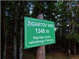 | Koča na Šumiku - Žigartov vrh
At 1346m, Žigartov vrh is the highest peak in the eastern part of Pohorje. An "observation" tower used to stand on the summit, but was erected on...
1 h 55 min |
 | Jurišče - Kršičevec
Kršičevec is a lesser known mountain located east of the village Jurišče in the Pivka Basin. From the grassy summit, where there is a registratio...
1 h 30 min |
 | Platak - Snježnik (via grlo)
Snježnik is a scenic mountain in the western part of Gorski Kotar. The summit offers a beautiful view of the Kvarner islands, the Gulf of Reška, ...
1 h 30 min |
| Platak - Snježnik (via crest)
Snježnik is a scenic mountain in the western part of Gorski Kotar. The summit offers a beautiful view of the Kvarner islands, the Gulf of Reška, ...
1 h 30 min |
 | Preval Vrh Ravni - Kojca
Kojca is a scenic peak rising south of Baška Grape. The hay pile on the top offers a beautiful view of the Lower Bohinj Mountains, the Škofjelošk...
1 h 20 min |
 | Zakojca - Kojca
Kojca is a scenic peak rising south of Baška Grape. The hay pile on the top offers a beautiful view of the Lower Bohinj Mountains, the Škofjelošk...
1 h 45 min |
| Jesenica - Kojca
Kojca is a scenic peak rising south of Baška Grape. The hay pile on the top offers a beautiful view of the Lower Bohinj Mountains, the Škofjelošk...
1 h 45 min |
 | Koča na Starem vrhu - Mladi vrh (via Stari vrh)
Mladi vrh is the senior neighbour of the better known Stari vrh, from which it is separated by a saddle. The top is covered with a sparse beech f...
1 h 40 min |
 | Preval - Mladi vrh
Mladi vrh is the senior neighbour of the better known Stari vrh, from which it is separated by a saddle. The top is covered with a sparse beech f...
2 h |
 | Črni Vrh - Čelkov vrh
Čelkov vrh is a 1106m high peak located to the south of Črni vrh. From the summit, which has a registration box and a stamp, there is a beautiful...
1 h 30 min |
 | Zadlog - Špičasti vrh
Špičasti vrh is a forested mountain located south of the village of Zadlog. To ensure that the peak is not without a view, a 13m high wooden look...
1 h 15 min |
 | Podkraj - Križna gora (Hrušica) (gentle path)
Križna gora is a 1162 m high peak located north of the village of Podkraj. From the top of the lookout tower, you can enjoy a beautiful view over...
1 h 20 min |
 | Podkraj - Sveti Duh (Hrušica)
The Sveti Duh Church is located just a few metres below the eponymous peak on the slopes of the forested Hrušice, a mountain range between Col, L...
1 h 15 min |
 | Koča na planini Stador - Kobilja glava
Kobilja glava is a 1475 m high peak located east of Tolmin. From the top with a cross, we have a beautiful view of the Krn, the Lower Bohinj Moun...
1 h 15 min |
| Podkraj - Srednja gora (Hrušica) (east path)
Srednja gora is a 1275 m high peak located in the central part of the forested Hrušice. The peak is covered with forest, and just a few minutes w...
1 h 30 min |
| Podkraj - Srednja gora (Hrušica) (west path)
Srednja gora is a 1275 m high peak located in the central part of the forested Hrušice. The peak is covered with forest, and just a few minutes w...
1 h 45 min |
 | Podkraj - Streliški vrh (Hrušica) (east path)
Streliški vrh is a 1266 m high mountain located in the central part of the forested Hrušice. From the top, which is partly covered with forest, w...
1 h 30 min |
| Podkraj - Streliški vrh (Hrušica) (west path)
Streliški vrh is a 1266 m high mountain located in the central part of the forested Hrušice. From the top, which is partly covered with forest, w...
1 h 20 min |
 | Ravne - Cerk
At 1192 m, Cerk is the highest peak of Borovška Gora, a mountain range located between the Kolpa River valley and Goteniškje Snežnik. From the to...
1 h 30 min |
 | Jeršiče - Mali Javornik (Javorniki)
Mali Javornik is a 1219 m high mountain located in the crest of the forested Javorniki Ridge. There is no view from the top due to the forest, bu...
1 h 50 min |
 | Solarji - Nagnoj
At 1193 m, Nagnoj is the second highest peak of the Kolovrat, a mountain range located between Tolmin and Venetian Slovenia. From the top, where ...
1 h 40 min |
 | Raspet - Kopa (Cimprovka)
Kopa is a 1360 m high peak or viewing pier from which we can enjoy a beautiful view of Cerkno, the hills surrounding the above-mentioned place, R...
1 h 10 min |
 | Dom na Paškem Kozjaku - Štrukljev vrh
Štrukljev vrh is one of the three main peaks of Paški Kozjak, a 10 km long, narrow and very steep limestone mountain range between the Paka and H...
1 h 30 min |
 | Čemernica / Tschemernitzen - Arihova peč / Arichwand
Arihova peč is a scenic rock cliff located near the Blesščeče mountain pasture / Rossalm. There is a wooden hut at the top of the cliff and the c...
1 h 25 min |
 | Avsa - Srednji vrh (on Matajur) (old path)
Srednji vrh is a 1320-metre high grassy peak located in the Matajur mountain range. The summit, which is a take-off point for paragliders, offers...
1 h 20 min |
 | St. John the Baptist on Ojstrica - Kozji vrh (at Košenjak)
Kozji vrh is a 1383-metre-high peak located above Pernice, and its height makes it the highest peak in the municipality of Muta....
1 h 35 min |
 | Chortata - Egklouvi road - Stavrota (Lefkada)
Stavrota or Elati mountain is a 1182 m high mountain on the Greek island Lefkada. The island, which lies in Ionian sea, is also known as Lefkas o...
1 h 50 min |
 | Koča na Šumiku - Veliki vrh (on Pohorje)
Veliki vrh is a 1344-metre-high peak located above the RTC Jakec - Trije kralji ski resort. The highest point of the peak is located in the fores...
2 h |
 | Mönichkirchen - Steinerne Stiege
Steinerne Stiege is a less prominent peak in the Wechsell mountain range....
1 h 35 min |
 | St. Vinzenz (St. Vinzenz) - Dreieckkogel
...
1 h 35 min |
 | Zelovo - Orlove stine (zahodna pot)
...
1 h 20 min |
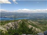
 | Planinski dom Orlove stine - Svilaja (mimo Umaca)
...
2 h |
 | Lišnjak (cesta na Promino) - Čavnovka (Promina) (mimo koče in po peš poti)
...
1 h 45 min |
 | Lišnjak (cesta na Promino) - Čavnovka (Promina) (mimo koče in po cesti)
...
1 h 45 min |
 | Malovan - Čardak (Tremzina)
...
2 h |
 | Račja vas - Orljak (Čičarija)
...
1 h 30 min |
 | Križišče pod Zvonikom - Bitoraj
...
1 h 30 min |
 | Omar - Črni vrh (nad Klenovico)
...
1 h 45 min |